Difference between revisions of "2020-05-26 61 30"
m (Location) |
|||
| Line 14: | Line 14: | ||
[[Virgin Graticule]], here I come! This is in such a convenient location that I must go and visit it. Unless weather is terrible, I can either cycle all the way (about 180 kilometres in total) or travel by train to Kitee railway station and cycle the rest (only 54 kilometres in total). The hashpoint will be easy to reach because it is in accessible forest and close to a road. | [[Virgin Graticule]], here I come! This is in such a convenient location that I must go and visit it. Unless weather is terrible, I can either cycle all the way (about 180 kilometres in total) or travel by train to Kitee railway station and cycle the rest (only 54 kilometres in total). The hashpoint will be easy to reach because it is in accessible forest and close to a road. | ||
| − | |||
== Expedition == | == Expedition == | ||
| + | I left my home in Joensuu for the geohash at about 14:10. I decided to cycle to the hashpoint first and then either cycle back home or to Kitee railway station depending on my condition. It took me until late afternoon to get going, but I would still have enough time to catch the last train of the day, at 22:25. The weather was partly cloudy, with temperature close to 20 °C during the day. It was warm but not yet too hot. | ||
| − | + | My route went via Reijola, Onkamo, Tohmajärvi and Uusi-Värtsilä and then through sparsely populated countryside towards the hashpoint. I took a short detour to visit Hatunvaara, a high hill with nice views. After about 98 kilometres of cycling, I entered the final forest road and parked my bicycle. The hashpoint was only 50 metres away, and I could walk to it, though not as effortlessly as I had hoped. The point was located in a very dense young spruce forest that was almost impossible to walk through, and there were some fallen ones blocking the way even more severely. I found a way around the worst parts and finally reached the hashpoint. Afterwards I found a much easier way out and back to the bicycle. | |
| + | |||
| + | At this point, I noticed it was getting late: it was already past eight, and it would take me until at least one in the morning if I returned home by cycling. I was not terribly tired, but it still felt like the best idea was to cycle to Kitee station and catch the train. I still had plenty of time and no need to hurry. The stretch from the hashpoint to Kitee was the most beautiful in terms of landscapes, among the most beautiful I have ever experienced. There were many fields and forests in hilly terrain with stunning views and a nice view to lake Hyypii. I stopped many times to take pictures, and ultimately I had so many that I had a hard time having to pick only a few of them. | ||
| + | |||
| + | The sun set at about ten o'clock, and the temperature started to decrease gradually. I was almost done though. I arrived at the railway station at five past ten and had plenty of time to buy a train ticket and find a geocache there. I took the train to Joensuu and cycled from Joensuu station to home. The total distance of the trip was 186.3 km, of which I cycled 128.7 km, walked 0.2 km and travelled 57.1 km by train. | ||
== Photos == | == Photos == | ||
| − | <gallery perrow=" | + | <gallery perrow="6"> |
| + | Image:2020-05-26_61_30_01-honkavaara1.jpg | The petrol station in Honkavaara. | ||
| + | Image:2020-05-26_61_30_02-honkavaara2.jpg | An eukterion – Eastern Orthodox Christians' house of prayer – in Honkavaara. | ||
| + | Image:2020-05-26_61_30_03-honkavaara3.jpg | Looking ahead in Honkavaara. | ||
| + | Image:2020-05-26_61_30_04-onkamo.jpg | At a bus stop in Onkamo. | ||
| + | Image:2020-05-26_61_30_05-tohmajärvi.jpg | The town of Tohmajärvi. | ||
| + | Image:2020-05-26_61_30_06-viper.jpg | A roadkill viper (''Vipera berus''). | ||
| + | Image:2020-05-26_61_30_07-road1.jpg | The country road, somewhere between Uusi-Värtsilä and Kantosyrjä. | ||
| + | Image:2020-05-26_61_30_08-bicycle.jpg | The bicycle parked near the hashpoint, 50 metres to go. | ||
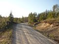
| + | Image:2020-05-26_61_30_09-road2.jpg | The last gravel road that I had to ride on. | ||
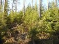
| + | Image:2020-05-26_61_30_10-forest.jpg | Walking through this forest was just as fun as it looks like in the picture. | ||
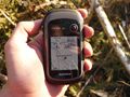
| + | Image:2020-05-26_61_30_11-gpsr.jpg | Hashpoint reached! | ||
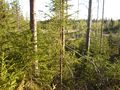
| + | Image:2020-05-26_61_30_12-hashpoint.jpg | View from the hashpoint, not very interesting. | ||
| + | Image:2020-05-26_61_30_13-selfie.jpg | Selfie at the hashpoint. | ||
| + | Image:2020-05-26_61_30_14-scratches.jpg | I was attacked by something in the forest, probably a velociraptor. | ||
| + | Image:2020-05-26_61_30_15-fields1.jpg | View to a field in Salo. | ||
| + | Image:2020-05-26_61_30_16-fields2.jpg | Another view to fields in Niemenpuoli. | ||
| + | Image:2020-05-26_61_30_17-lake.jpg | View to lake Hyypii. | ||
| + | Image:2020-05-26_61_30_18-kitee.jpg | The town of Kitee. | ||
| + | Image:2020-05-26_61_30_19-sunset.jpg | The sun is about to set. | ||
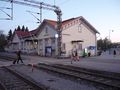
| + | Image:2020-05-26_61_30_20-kitee_station.jpg | Kitee railway station. | ||
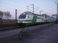
| + | Image:2020-05-26_61_30_21-train.jpg | The train is arriving. | ||
| + | Image:2020-05-26_61_30_22-joensuu_station.jpg | Joensuu railway station. | ||
</gallery> | </gallery> | ||
| Line 26: | Line 52: | ||
{{#vardefine:ribbonwidth|800px}} | {{#vardefine:ribbonwidth|800px}} | ||
| − | -- | + | {{land geohash | latitude = 61 | longitude = 30 | date = 2020-05-26 | name = Kripakko}} |
| − | + | {{Velociraptor geohash | latitude = 61 | longitude = 30 | date = 2020-05-26 | name = Kripakko}} | |
| − | + | {{Minesweeper geohash | graticule = Joensuu, Finland | ranknumber = 4 | n = true | e = true | se = true | s = true | name = Kripakko}} | |
| + | {{Virgin graticule | latitude = 61 | longitude = 30 | date = 2020-05-26 | name = Kripakko}} | ||
| − | |||
[[Category:Expeditions]] | [[Category:Expeditions]] | ||
| − | |||
[[Category:Expeditions with photos]] | [[Category:Expeditions with photos]] | ||
| − | |||
| − | |||
| − | |||
| − | |||
| − | |||
[[Category:Coordinates reached]] | [[Category:Coordinates reached]] | ||
| − | |||
| − | |||
| − | |||
| − | |||
| − | |||
| − | |||
| − | |||
| − | |||
| − | |||
| − | |||
| − | |||
| − | |||
| − | |||
| − | |||
| − | |||
| − | |||
| − | |||
{{location|FI|13}} | {{location|FI|13}} | ||
Revision as of 20:26, 27 May 2020
| Tue 26 May 2020 in 61,30: 61.9956233, 30.3082186 geohashing.info google osm bing/os kml crox |
Location
In a forest in the backwoods of Kitee, also about three kilometres from the Russian border.
Participants
Plans
Virgin Graticule, here I come! This is in such a convenient location that I must go and visit it. Unless weather is terrible, I can either cycle all the way (about 180 kilometres in total) or travel by train to Kitee railway station and cycle the rest (only 54 kilometres in total). The hashpoint will be easy to reach because it is in accessible forest and close to a road.
Expedition
I left my home in Joensuu for the geohash at about 14:10. I decided to cycle to the hashpoint first and then either cycle back home or to Kitee railway station depending on my condition. It took me until late afternoon to get going, but I would still have enough time to catch the last train of the day, at 22:25. The weather was partly cloudy, with temperature close to 20 °C during the day. It was warm but not yet too hot.
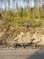
My route went via Reijola, Onkamo, Tohmajärvi and Uusi-Värtsilä and then through sparsely populated countryside towards the hashpoint. I took a short detour to visit Hatunvaara, a high hill with nice views. After about 98 kilometres of cycling, I entered the final forest road and parked my bicycle. The hashpoint was only 50 metres away, and I could walk to it, though not as effortlessly as I had hoped. The point was located in a very dense young spruce forest that was almost impossible to walk through, and there were some fallen ones blocking the way even more severely. I found a way around the worst parts and finally reached the hashpoint. Afterwards I found a much easier way out and back to the bicycle.
At this point, I noticed it was getting late: it was already past eight, and it would take me until at least one in the morning if I returned home by cycling. I was not terribly tired, but it still felt like the best idea was to cycle to Kitee station and catch the train. I still had plenty of time and no need to hurry. The stretch from the hashpoint to Kitee was the most beautiful in terms of landscapes, among the most beautiful I have ever experienced. There were many fields and forests in hilly terrain with stunning views and a nice view to lake Hyypii. I stopped many times to take pictures, and ultimately I had so many that I had a hard time having to pick only a few of them.
The sun set at about ten o'clock, and the temperature started to decrease gradually. I was almost done though. I arrived at the railway station at five past ten and had plenty of time to buy a train ticket and find a geocache there. I took the train to Joensuu and cycled from Joensuu station to home. The total distance of the trip was 186.3 km, of which I cycled 128.7 km, walked 0.2 km and travelled 57.1 km by train.
Photos
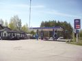
The petrol station in Honkavaara.
An eukterion – Eastern Orthodox Christians' house of prayer – in Honkavaara.
Looking ahead in Honkavaara.
At a bus stop in Onkamo.
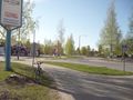
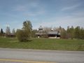
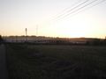
The town of Tohmajärvi.
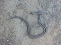
A roadkill viper (Vipera berus).
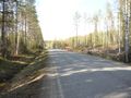
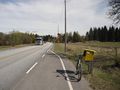
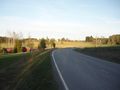
The country road, somewhere between Uusi-Värtsilä and Kantosyrjä.
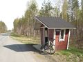
The bicycle parked near the hashpoint, 50 metres to go.
The last gravel road that I had to ride on.
Walking through this forest was just as fun as it looks like in the picture.
Hashpoint reached!
View from the hashpoint, not very interesting.
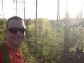
Selfie at the hashpoint.
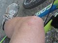
I was attacked by something in the forest, probably a velociraptor.
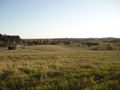
View to a field in Salo.
Another view to fields in Niemenpuoli.
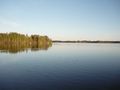
View to lake Hyypii.
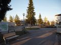
The town of Kitee.
The sun is about to set.
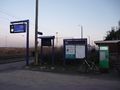
Kitee railway station.
The train is arriving.
Joensuu railway station.


Achievements
Kripakko earned the Land geohash achievement
|
Kripakko earned the Velociraptor Geohash Achievement
|
Kripakko achieved level 4 of the Minesweeper Geohash achievement
|