Difference between revisions of "2020-07-31 48 7"
From Geohashing
| Line 34: | Line 34: | ||
| longitude = 7 | | longitude = 7 | ||
| date = 2020-07-31 | | date = 2020-07-31 | ||
| − | | name = Baarde | + | | name = [[User:Baarde|Baarde]] |
}} | }} | ||
{{bicycle geohash | {{bicycle geohash | ||
| Line 40: | Line 40: | ||
| longitude = 7 | | longitude = 7 | ||
| date = 2020-07-31 | | date = 2020-07-31 | ||
| − | | name = Baarde | + | | name = [[User:Baarde|Baarde]] |
| distance = 26 km | | distance = 26 km | ||
| bothways = true | | bothways = true | ||
| Line 48: | Line 48: | ||
| longitude = 7 | | longitude = 7 | ||
| date = 2020-07-31 | | date = 2020-07-31 | ||
| − | | name = Baarde | + | | name = [[User:Baarde|Baarde]] |
| count = 1 | | count = 1 | ||
| reached = true | | reached = true | ||
Revision as of 19:54, 11 August 2020
| Fri 31 Jul 2020 in 48,7: 48.3069398, 7.6326234 geohashing.info google osm bing/os kml crox |
Location
In a forest near Neunkirch (Friesenheim).
Participants
Plans
The coordinates are located near the northern branch of the Rhone-Rhine Canal. Ideal for a bike ride on the EuroVelo 15.
Expedition
I took the EuroVelo 15 at Marckolsheim. From there it was a straight route along the Rhone-Rhine Canal until Neunkirch. The coordinate was located in a small forest near the hamlet, in the middle of a half-buried path. I arrived there at 13:10. Easy!
In order to use a different route on the way back, I continued a little bit on the EV15, crossed the Rhine with the ferry at Rhinau and took a small detour across Germany before crossing back on the Sasbach-Marckolsheim bridge.
Photos
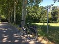
Taking the EV15 at Marckolsheim
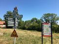
Exiting the EV15 at Neunkirch
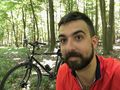
Stupid grin
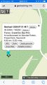
Coordinates reached


Achievements
Baarde earned the Land geohash achievement
|
Baarde earned the Bicycle geohash achievement
|
Baarde earned the Two to the N achievement
|