Difference between revisions of "2020-08-24 48 11"
m (Location) |
|||
| Line 40: | Line 40: | ||
[[Category:Expeditions with photos]] | [[Category:Expeditions with photos]] | ||
[[Category:Coordinates reached]] | [[Category:Coordinates reached]] | ||
| + | {{location|DE|BY|M}} | ||
Latest revision as of 08:42, 31 August 2020
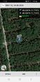
| Mon 24 Aug 2020 in 48,11: 48.0340621, 11.7758476 geohashing.info google osm bing/os kml crox |
Location
In a forest between Putzbrunn and Oberpframmern, south-east of Munich
Participants
Expedition
I set out to drive to this cache after a day's work in the homeoffice. As too many times Google maps insisted that I would be able to drive over the gravel roads in the forest, but as most of the time in Germany this is forbidden. As a consequence I had to walk about 1 km from my parking spot. But a bit of activity at the fresh air never does any harm, doesn't it? After a while I reached the coordinates, took my pictures and then when I looked at the ground I saw a piece of birch tree bark that resembled a geocaching logbook. I couldn't resist and had to sign this nature given logbook ;-) After carefully placing this first ever (?) Geohashing logbook on a tree stump I walked back to my car and returned home.
Photos
Logproof
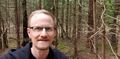
Standing at the hash
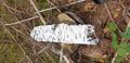
Nature'sLogbook
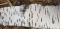
first ever (?) signed Geohashing logbook
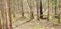
View from hashpoint
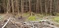
Looking in the opposite direction