Difference between revisions of "2013-02-26 56 -2"
imported>FippeBot m (Location) |
|||
| Line 31: | Line 31: | ||
== Expedition == | == Expedition == | ||
<!-- how it all turned out. your narrative goes here. --> | <!-- how it all turned out. your narrative goes here. --> | ||
| − | Wasindear's plan was mostly successful, but | + | Wasindear's plan was mostly successful, but they had to dismount for the final bit, as the field was far to muddy to allow for cycling. |
<!-- I copied this from the user page as it makes it clear that coordinates were reached (Palmpje) --> | <!-- I copied this from the user page as it makes it clear that coordinates were reached (Palmpje) --> | ||
| − | I cycled from the town of St Andrews to the location. The co-ordinates were unfortunately in a very muddy field which was private land and had pigs on | + | I cycled from the town of St Andrews to the location. The co-ordinates were unfortunately in a very muddy field which was private land and had pigs on. I also realised when I arrived that I had no way of showing the GPS on my phone, and there was no data connection available to use Google Maps. I had to settle for the very tedious method of geo-tagging pictures until I was standing as close as I could get. |
The kind couple who took my picture happened to be from my home county, the only reason this is interesting is because my home county is about 500 miles away from the geohash location. | The kind couple who took my picture happened to be from my home county, the only reason this is interesting is because my home county is about 500 miles away from the geohash location. | ||
All in all it was good fun, and I have discovered a few flaws in my setup that need to be remedied, namely having a way of showing GPS co-ordinates in raw terms on my phone. | All in all it was good fun, and I have discovered a few flaws in my setup that need to be remedied, namely having a way of showing GPS co-ordinates in raw terms on my phone. | ||
Revision as of 14:25, 23 September 2020
| Tue 26 Feb 2013 in 56,-2: 56.2350292, -2.6707214 geohashing.info google osm bing/os kml crox |
Location
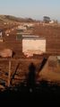
Next to the sea, in a muddy field with pigs.
Participants
Plans
Wasindear's plan was to cycle from St Andrew's to the location. Though it was hatched on a whim.
Expedition
Wasindear's plan was mostly successful, but they had to dismount for the final bit, as the field was far to muddy to allow for cycling.
I cycled from the town of St Andrews to the location. The co-ordinates were unfortunately in a very muddy field which was private land and had pigs on. I also realised when I arrived that I had no way of showing the GPS on my phone, and there was no data connection available to use Google Maps. I had to settle for the very tedious method of geo-tagging pictures until I was standing as close as I could get. The kind couple who took my picture happened to be from my home county, the only reason this is interesting is because my home county is about 500 miles away from the geohash location. All in all it was good fun, and I have discovered a few flaws in my setup that need to be remedied, namely having a way of showing GPS co-ordinates in raw terms on my phone.
Photos
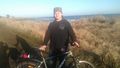
Wasindear and his bike relax after a tiring journey.
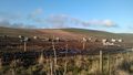
Darn it, those pigs beat me to the location, and it looks like they intend to stay overnight.
Also they are cute.


