Difference between revisions of "2020-10-17 48 11"
From Geohashing
m (Location) |
|||
| Line 35: | Line 35: | ||
[[Category:Expeditions with photos]] | [[Category:Expeditions with photos]] | ||
[[Category:Coordinates reached]] | [[Category:Coordinates reached]] | ||
| + | {{location|DE|BY|M}} | ||
Latest revision as of 16:42, 19 October 2020
| Sat 17 Oct 2020 in 48,11: 48.0062021, 11.7146370 geohashing.info google osm bing/os kml crox |
Location
In a forest south of Munich, about 30m off from the gravel road.
Participants
Expedition
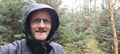
My wife and I took the electric car for a short drive and walked the remaining 300 m to the hash. As it had started to rain when we left the house it was a bit of a challenge to make my way through the underwood without getting totally soaked from the wet branches. Using the umbrella as a stick to beat the droplets off from the branches allowed me to reach the coordinates. After taking my photos I made my way back through the trees to the little road where the wife had remained waiting (not everyone is as crazy for trying to get to some random coordinates...).
Photos

Logpoof
Hash in the rain
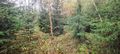
Trees, trees and
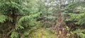
more trees
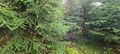
Wet way back