Difference between revisions of "2021-03-02 51 9"
(expedition report for Kassel-Harleshausen) |
m (Location) |
||
| Line 38: | Line 38: | ||
[[Category:Coordinates reached]] | [[Category:Coordinates reached]] | ||
| + | {{location|DE|HE|KS|city=true}} | ||
Latest revision as of 22:42, 3 March 2021
| Tue 2 Mar 2021 in 51,9: 51.3296310, 9.4206861 geohashing.info google osm bing/os kml crox |
Location
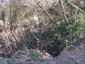
The hash lay in the shrub at the Todenhäuser Graben in Kassel.
Participants
Plans
As the hash lay in Kassel I planned a Tron.
Expedition
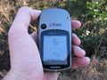
It started good. I walked along the streets. I took two buses. I walked to the hash. I crossed the Todenhäuser Graben, today with water, but sometimes the creek is dry. The way on the northers side was very muddy, so I tried at first to arrive from the south. I fighted through the thorns but after some steps they hindered me. The GPS showed the hash 11 meters away. But in a 14 meters wide shrub the hash should be reachable from the other side, but it broke the Tron. And standing there, the GPS showed me 12 meters away. As I was on both side of the 14 meters wide shrub, and both times it showed the hash laying three meter away from the edge of the shrub, so I was there. But the Tron was broken.
Photos
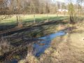
water in the Todenhäuser Graben
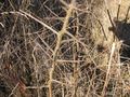
thorns
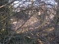
too much thorns

11 meters away means three meters from the other side
12 meters from the north means three meters from the other side
the location
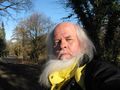
standing there I was not happy


