Difference between revisions of "2021-04-06 42 -83"
m (Location) |
m (Linkfix) |
||
| Line 57: | Line 57: | ||
<!-- =============== USEFUL CATEGORIES FOLLOW ================ | <!-- =============== USEFUL CATEGORIES FOLLOW ================ | ||
Delete the next line ONLY if you have chosen the appropriate categories below. If you are unsure, don't worry. People will read your report and help you with the classification. --> | Delete the next line ONLY if you have chosen the appropriate categories below. If you are unsure, don't worry. People will read your report and help you with the classification. --> | ||
| − | [[Category: | + | [[Category:Expeditions]] |
[[Category:Expeditions with photos]] | [[Category:Expeditions with photos]] | ||
[[Category:Expeditions with videos]] | [[Category:Expeditions with videos]] | ||
Latest revision as of 21:21, 13 April 2021
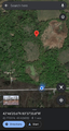
| Tue 6 Apr 2021 in 42,-83: 42.7723746, -83.6260530 geohashing.info google osm bing/os kml crox |
Location
A field south of Holly, Michigan
Participants
Plans
Drive to Grace Missionary Baptist Church and bike to the hashpoint from there.
Expedition
I arrived at the church parking lot around 4:30pm and planned my route.
The closest public street to the hashpoint was Rattalee Lake Road between Buckhorn Lake and Milford, which was a little over a mile away by road. I chose to walk west along Fenton, then begin biking south on Buckhorn Lake.
Shortly after I crossed the CN rail line, a freight train passed through heading towards Flint which lent itself to a few good photos.
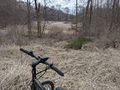
Once I reached the point along Rattalee Lake closest to the hashpoint, I left my bike within view a safe distance from the road and continued on foot. The hashpoint was across and slightly northeast of a small wetlands area with a pond in the middle. Unfortunately, after just a few feet the wet soil became too muddy and deep to travel across without risking safety (or at best, ruining my shoes).
As a final effort, I returned to my bike and traveled north of the hashpoint back to Milford Road. A dry field appeared to lead towards the hashpoint from the north; however, this was private property with posted signage. As such this expedition was not a success.
I made the best of it though: Before leaving, I visited the Holly rail diamond and got some ice cream downtown before a rainstorm rolled through. Better luck next time!
Photos
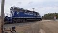
Probably heading to Dow Chemical if I had to guess.
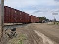
Just passing through!
The initial approach.
Two wheels will take me no further.
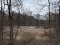
Too swampy to keep going.
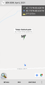
277 feet was as close as I could get.
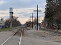
The historic Holly train station.
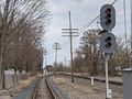
The Holly CN/CSX diamond junction.


.png)

