Difference between revisions of "2021-05-16 52 9"
(New report) |
Clearlucid9 (talk | contribs) |
||
| Line 36: | Line 36: | ||
</gallery> | </gallery> | ||
| − | |||
| − | |||
| − | |||
| − | |||
__NOTOC__ | __NOTOC__ | ||
| Line 45: | Line 41: | ||
[[Category:Coordinates reached]] | [[Category:Coordinates reached]] | ||
[[Category:Expeditions with photos]] | [[Category:Expeditions with photos]] | ||
| − | {{location|DE| | + | {{location|DE|BY|M}} |
| − | [[Category:Expeditions by | + | [[Category:Expeditions by Clearlucid9]] |
Revision as of 16:58, 19 May 2021
| Sun 16 May 2021 in Hannover: 52.2891630, 9.8780594 geohashing.info google osm bing/os kml crox |
Location
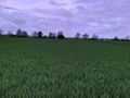
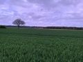
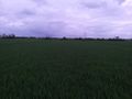
This Geohash is located on a field in Ingeln.
Participants
Expedition
Barefoot cycling is easier than one might think. A herd of sheep witnessed me leaving the Shire for my quest.
I took two stops to eat some banana bread, the first time in Wülferode and the second time at 52.2977,9.8639. A man in a car asked me if my feet were getting cold. I think he was hoping for an explanation, but thinking that the explanation would confuse him even more, I just told him that I am fine. I left the bicycle at 52.2948,9.86655 and continued on foot for the last kilometer.
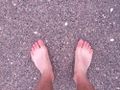
My feet got slightly dirty in the field, but I located the coordinates and recorded proof. I decided to not leave my ring there. Afterwards, I walked back to my bicycle and cycled back home.
Photos
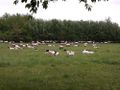
Sheep in the Shire
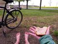
The first stop in Wülferode: Bare feet, food and a ring all in one picture
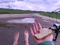
The second stop
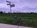
Left the bicycle there...
...to continue on foot
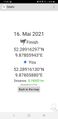
Proof
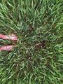
The Geohash
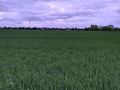
Surroundings
Surroundings
Surroundings
Surroundings
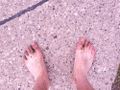
Dirty feet


