Difference between revisions of "2021-11-29 52 1"
From Geohashing
m (→Coordinates Reached) |
m (→Achievements) |
||
| Line 32: | Line 32: | ||
== Achievements == | == Achievements == | ||
| + | |||
| + | {{Sourcerer_links | ||
| + | | prev = 2020-01-09_33_-13 | ||
| + | | curr = 2021-11-29_52_1 | ||
| + | | next = | ||
| + | | date = 2021-11-29 | ||
| + | }} | ||
{{Déjà vu geohash | {{Déjà vu geohash | ||
| Line 39: | Line 46: | ||
| olddate = 2018-08-04 | | olddate = 2018-08-04 | ||
| name = [[User:Sourcerer|Sourcerer]] | | name = [[User:Sourcerer|Sourcerer]] | ||
| − | |||
| − | |||
| − | |||
| − | |||
| − | |||
| − | |||
| − | |||
}} | }} | ||
Revision as of 16:40, 29 November 2021
| Mon 29 Nov 2021 in Norwich: 52.5244213, 1.3174208 geohashing.info google osm bing/os kml crox |
Location
On the Boudicca Way long distance path, Saxlingham. Norfolk.
Planning
An easy one to reach.
Participants
Expedition
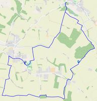
Sourcerer re-visited this point after walking here on July 4th, 2018, walking 7.7 miles near Saxlingham and Shotesham. Saxlingham and Shotesham Walk
Photos
- Gallery
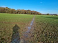
Hashpoint and woodland
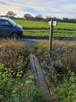
Railway sleeper bridge
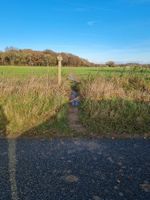
View north, from the road
Proof of earlier visit


Achievements
Expeditions and Plans
| 2021-11-29 | ||
|---|---|---|
| Norwich, United Kingdom | Sourcerer | On the Boudicca Way long distance path, Saxlingham. Norfolk. |
Sourcerer's Expedition Links
2020-01-09_33_-13 - 2021-11-29_52_1 - LAST (until now) - KML file download of Sourcerer's expeditions for use with Google Earth.
Sourcerer earned the Déjà Vu Geohash Achievement
|