Difference between revisions of "2021-12-10 40 -4"
(Created page with "<!-- [[Image:{{{image|IMAGE}}}|thumb|left]] --> <!-- Remove this section if you don't want an image at the top (left) of your report. You should remove the "Image...") |
|||
| Line 31: | Line 31: | ||
== Expedition == | == Expedition == | ||
<!-- how it all turned out. your narrative goes here. --> | <!-- how it all turned out. your narrative goes here. --> | ||
| + | I was not sure if this one was accessible, but it was not too far, so I | ||
| + | gave it a try. In the end, it turned out to be even an easy one. | ||
| + | |||
| + | Yet again, I knew already the route quite well. After 30 expeditions, | ||
| + | I would have to increase my radius of operations to discover | ||
| + | new roads. Currently, the chosen maximum distance (as the crow flies) | ||
| + | from my home base is 70 km. I use an algorithm to select the graticule that | ||
| + | yields points evenly distributed in a circle with that radius. | ||
| + | |||
| + | If you always use your home graticule, the area you cover is in general not | ||
| + | centered on your home base. If you use the graticule with the nearest geohash, | ||
| + | it ''is'' centered, but it has the shape of a graticule | ||
| + | (approximately a trapezoid on the sphere of the Earth) at your latitude. | ||
| + | In order to obtain a circle, | ||
| + | I randomly select graticules (from a 5 x 5 grid centered on my home graticule) | ||
| + | until I find one where the geohash of the day is closer than my maximum | ||
| + | distance. The current value of 70 km is in fact the minimum that ensures | ||
| + | that such a graticule can always be found. | ||
| + | This value is slightly latitude dependent and largest at the | ||
| + | equator. | ||
| + | |||
| + | A distance of 70 km as the crow flies typically translates into a | ||
| + | motorcycle ride of one and a half hours. For now, in the colder season | ||
| + | with shorter days, | ||
| + | I am not tempted to ride much longer. Maybe I increase my radius when | ||
| + | spring comes… | ||
== Tracklog == | == Tracklog == | ||
| Line 41: | Line 67: | ||
Image:2021-12-10_40_-4_L1040823.JPG | If I am not allowed to make fire, I should be permitted to go there in the first place. | Image:2021-12-10_40_-4_L1040823.JPG | If I am not allowed to make fire, I should be permitted to go there in the first place. | ||
Image:2021-12-10_40_-4_L1040824.JPG | However, it is locked… | Image:2021-12-10_40_-4_L1040824.JPG | However, it is locked… | ||
| − | Image:2021-12-10_40_-4_L1040825.JPG | … but here's an easy pedestrian bypass! I didn't see it in the Maps' streetview. | + | Image:2021-12-10_40_-4_L1040825.JPG | … but here's an easy pedestrian bypass! 😃 I didn't see it in the Maps' streetview. |
Image:2021-12-10_40_-4_L1040826.JPG | 677 meters behind the fence. | Image:2021-12-10_40_-4_L1040826.JPG | 677 meters behind the fence. | ||
Image:2021-12-10_40_-4_L1040827.JPG | Here I leave the path and walk cross country. | Image:2021-12-10_40_-4_L1040827.JPG | Here I leave the path and walk cross country. | ||
| Line 71: | Line 97: | ||
<!-- if you reached your coords: --> | <!-- if you reached your coords: --> | ||
[[Category:Coordinates reached]] | [[Category:Coordinates reached]] | ||
| + | |||
| + | [[Category:Easy geohash]] | ||
Revision as of 15:39, 13 December 2021
| Fri 10 Dec 2021 in 40,-4: 40.2661391, -4.1575474 geohashing.info google osm bing/os kml crox |
Location
Behind a locked gate, with an unexpected pedestrian bypass, near Méntrida.
Participants
Plans
Expedition
I was not sure if this one was accessible, but it was not too far, so I gave it a try. In the end, it turned out to be even an easy one.
Yet again, I knew already the route quite well. After 30 expeditions, I would have to increase my radius of operations to discover new roads. Currently, the chosen maximum distance (as the crow flies) from my home base is 70 km. I use an algorithm to select the graticule that yields points evenly distributed in a circle with that radius.
If you always use your home graticule, the area you cover is in general not centered on your home base. If you use the graticule with the nearest geohash, it is centered, but it has the shape of a graticule (approximately a trapezoid on the sphere of the Earth) at your latitude. In order to obtain a circle, I randomly select graticules (from a 5 x 5 grid centered on my home graticule) until I find one where the geohash of the day is closer than my maximum distance. The current value of 70 km is in fact the minimum that ensures that such a graticule can always be found. This value is slightly latitude dependent and largest at the equator.
A distance of 70 km as the crow flies typically translates into a motorcycle ride of one and a half hours. For now, in the colder season with shorter days, I am not tempted to ride much longer. Maybe I increase my radius when spring comes…
Tracklog
Photos
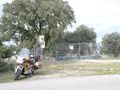
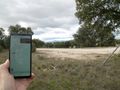
Convenient parking for the Goldwing at the gate.
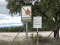
If I am not allowed to make fire, I should be permitted to go there in the first place.
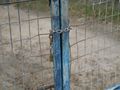
However, it is locked…
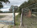
… but here's an easy pedestrian bypass! 😃 I didn't see it in the Maps' streetview.
677 meters behind the fence.
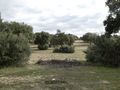
Here I leave the path and walk cross country.
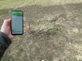
The geohash is right on this pile of wood.
I have put a bright stone on top of it. This is the direction from which I came.
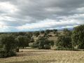
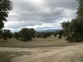
Nice view from a hilltop on the walk back.
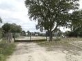
Back at the gate with the bypass and at the Goldwing.


