Difference between revisions of "2022-01-02 51 10"
From Geohashing
m (Uncommenting location) |
|||
| Line 16: | Line 16: | ||
== Plans == | == Plans == | ||
<!-- what were the original plans --> | <!-- what were the original plans --> | ||
| − | + | Drive to Weißenborn by car and do a little walk to the hash. | |
== Expedition == | == Expedition == | ||
| − | <!-- how it all turned out. your narrative goes here | + | <!-- how it all turned out. your narrative goes here --> |
| + | As planned, I drove to Weißenborn and parked my car along the road to Rambach, so it were only some 700 meters to the hash. However the terrain was pretty steep short before the hash and since I tried a wrong access, I had to get down into a ditch, to reach the hash. After taking proof and some pics, I noticed that there had been a much easier way to reach the hash, so I decided to do a little detour to get back to my car and drove a little further to Rambach, where I did a bigger walk to find some geocaches as well... | ||
== Photos == | == Photos == | ||
<gallery> | <gallery> | ||
| − | Image: | + | Image:2022-01-02_51_10_001.jpg|On my way to the hash |
| − | + | Image:2022-01-02_51_10_002.jpg|The hash was behind those trees in a ditch | |
| − | Image: | + | Image:2022-01-02_51_10_003.jpg|The hash |
| − | + | Image:2022-01-02_51_10_004.jpg|Proof | |
| − | Image: | ||
| − | |||
| − | |||
| − | Image: | ||
</gallery> | </gallery> | ||
| Line 36: | Line 33: | ||
[[Category:Expeditions with photos]] | [[Category:Expeditions with photos]] | ||
[[Category:Coordinates reached]] | [[Category:Coordinates reached]] | ||
| − | + | {{location|DE|TH|EIC}} | |
| − | |||
Revision as of 18:06, 2 January 2022
| Sun 2 Jan 2022 in 51,10: 51.1186794, 10.1456915 geohashing.info google osm bing/os kml crox |
Location
In a forest east of Weißenborn
Participants
Plans
Drive to Weißenborn by car and do a little walk to the hash.
Expedition
As planned, I drove to Weißenborn and parked my car along the road to Rambach, so it were only some 700 meters to the hash. However the terrain was pretty steep short before the hash and since I tried a wrong access, I had to get down into a ditch, to reach the hash. After taking proof and some pics, I noticed that there had been a much easier way to reach the hash, so I decided to do a little detour to get back to my car and drove a little further to Rambach, where I did a bigger walk to find some geocaches as well...
Photos
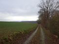
On my way to the hash
- 2022-01-02 51 10 002.jpg
The hash was behind those trees in a ditch

The hash

Proof


