Difference between revisions of "Jasper, Alberta"
From Geohashing
imported>Dunstergirl |
m (Replacing Peeron with Geohashing.info) |
||
| Line 1: | Line 1: | ||
[[Image:Ramparts.jpg|border|300px|left]] | [[Image:Ramparts.jpg|border|300px|left]] | ||
| − | The Jasper, Alberta [[graticule]] is located at | + | The Jasper, Alberta [[graticule]] is located at {{Today's location|lat=52|lon=-118|text=latitude 52, longitude -118}}. Straddling the border between Alberta and BC, as well as the Continental Divide, it includes the town of Jasper and a chunk of Jasper National Park in Alberta, as well as a large chunk of Mt. Robson Provincial Park in British Columbia (though not Mt. Robson itself), including the headwaters of the Fraser River, and a large portion of Kinbasket Lake (part of the Columbia River system) as well as bits of other provincial parks in British Columbia. Spectacular barely describes this graticule. |
{{graticule | {{graticule | ||
Latest revision as of 17:02, 15 January 2022
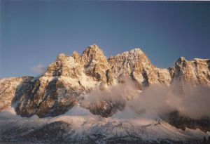
The Jasper, Alberta graticule is located at latitude 52, longitude -118. Straddling the border between Alberta and BC, as well as the Continental Divide, it includes the town of Jasper and a chunk of Jasper National Park in Alberta, as well as a large chunk of Mt. Robson Provincial Park in British Columbia (though not Mt. Robson itself), including the headwaters of the Fraser River, and a large portion of Kinbasket Lake (part of the Columbia River system) as well as bits of other provincial parks in British Columbia. Spectacular barely describes this graticule.
| Grande Cache | Muskeg River | Hinton |
| Valemount, British Columbia | Jasper | Jasper National Park |
| Vavenby, British Columbia | Revelstoke, British Columbia | Rogers Pass, British Columbia |
|
Today's location: not yet announced | ||
Geohashes
None yet.
