Difference between revisions of "2020-02-26 53 9"
m (clearing up username confusion) |
(→Photos: photos 40 of 120) |
||
| Line 12: | Line 12: | ||
==Photos== | ==Photos== | ||
| − | + | <gallery> | |
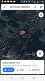
| − | + | File:2020-02-26 53 9 7.png | proof 1 | |
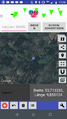
| + | File:2020-02-26 53 9 8.png | proof 2 | ||
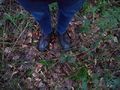
| + | File:2020-02-26 53 9 1.jpg | the hash | ||
| + | File:2020-02-26 53 9 2.jpg | π π π | ||
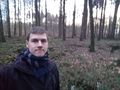
| + | File:2020-02-26 53 9 3.jpg | very stupid grin | ||
| + | File:2020-02-26 53 9 4.jpg | pano 1 | ||
| + | File:2020-02-26 53 9 5.jpg | pano 2 | ||
| + | File:2020-02-26 53 9 6.jpg | fallen spider tree | ||
</gallery> | </gallery> | ||
Latest revision as of 16:38, 16 January 2022
| Wed 26 Feb 2020 in 53,9: 53.7133225, 9.8550218 geohashing.info google osm bing/os kml crox |
Location
in a forest in Quickborn, Schleswig-Holstein
Participants
Expedition
π π π (log from April 2020)
I took the train to Quickborn and then cycled the last 5 km to the hash, the last 300 m on a muddy forest path. Then, I walked the last 80 m to the location, firstly way off course because positioning in the forest was very poor. I got to a promising area after stumbling about for a few minutes, but my location point kept jumping. I trawled through the whole area, oscillating by 20 or 30 m, then after maybe 10 min settled on a spot near a large puddle that kind of fit to the satellite picture – probably the longest or second-longest hashdance I've ever done. The sun had already set. I took some dim pictures, which also took a while because my phone refused to take panoramas, examined an interesting nearby tree, then walked back on a kind-of path. I had to hurry to catch a train in time and duly made it to the station after almost racing there, then rode home.
Photos
proof 1
proof 2
the hash
π π π
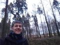
very stupid grin

pano 1

pano 2
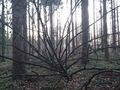
fallen spider tree


Achievements
Land geohash, Bicycle geohash, Public transport geohash