Difference between revisions of "2020-05-03 53 9"
m (clearing up username confusion) |
(→Photos: photos 43 of 120) |
||
| Line 11: | Line 11: | ||
==Photos== | ==Photos== | ||
| − | + | <gallery> | |
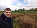
| − | + | File:2020-05-03 53 9 6.jpg | proof 1 | |
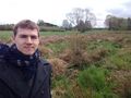
| + | File:2020-05-03 53 9 7.jpg | proof 2 | ||
| + | File:2020-05-03 53 9 1.jpg | the hash | ||
| + | File:2020-05-03 53 9 2.jpg | π π π | ||
| + | File:2020-05-03 53 9 3.jpg | pretty much the same | ||
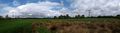
| + | File:2020-05-03 53 9 4.jpg | pano 1 | ||
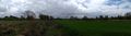
| + | File:2020-05-03 53 9 5.jpg | pano 2 | ||
</gallery> | </gallery> | ||
Latest revision as of 17:00, 16 January 2022
| Sun 3 May 2020 in 53,9: 53.7366214, 9.9615949 geohashing.info google osm bing/os kml crox |
Location
on a grassy field in Quickborn-Heide, Schleswig-Holstein
Participants
Expedition
I took off shortly before midday and cycled 6.7 km to the hashpoint. At the end of a small path there was a gate that lead to the field on which the hash was located; I parked my bike, stepped across the small fence and walked 110 m across the grass. Unfortunately, the location was on the only part of the field that was unchecked and had uneven vegetation with a small natural ditch on the sides. I went around and tried to access the hash from behind, but underestimated the amount of water in the grass from the previous day's heavy rains and got my foot wet. I jumped across the ditch, found the coordinates 7 m from it and took photos, which took time because my phone, as always, refused to take screenshots. Then I walked back across the field and rode home.
Photos
proof 1

proof 2
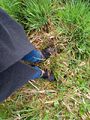
the hash
π π π
pretty much the same
pano 1
pano 2


Achievements
Land geohash, Bicycle geohash