Difference between revisions of "2022-05-25 38 -86"
Michael5000 (talk | contribs) (→Location) |
Michael5000 (talk | contribs) |
||
| Line 1: | Line 1: | ||
| − | + | {{meetup graticule | |
| − | |||
| − | |||
| − | |||
| − | |||
| − | |||
| − | |||
| − | |||
| − | |||
| lat={{#explode:{{SUBPAGENAME}}| |1}} | | lat={{#explode:{{SUBPAGENAME}}| |1}} | ||
| lon={{#explode:{{SUBPAGENAME}}| |2}} | | lon={{#explode:{{SUBPAGENAME}}| |2}} | ||
| Line 18: | Line 10: | ||
== Participants == | == Participants == | ||
| − | |||
| − | |||
| − | + | *[[User:Michael5000|Michael5000]], on his 250th Expedition. | |
| − | |||
== Expedition == | == Expedition == | ||
| − | |||
| − | + | Starting from Sparta, Kentucky, I went south as far as the northern suburbs of Louisville, where I stopped at a Starbucks to check in with work. I checked in with the staff about how to pronounce the name of the city. "Say it like you have pebbles in your mouth," one said. "No, say it like you're just waking up," said another. | |
| − | + | ||
| + | Then, through the city and across the Ohio River into Indiana and then on US 150 to Palmyra, then State 135 north to the Vincennes Trail, a narrow and very hilly road through woods and little villages and finally out to flat farmland where the hashpoint was. I pulled into a driveway off the remote rural road and was immediately joined by a polite young farmer or farm worker, who gave the traditional offer of assistance that people give when they're too polite to say "what the hell are you up to, anyway?" I responded with the traditional blather that means "don't worry, I'm just a harmless eccentric and if you roll with it I'll be out of your hair in two minutes." | ||
| + | |||
| + | Then a guy came by on a tractor to mow the hashpoint, along with the rest of the road shoulder of course. All in all, it was pretty lively for such a remote hashpoint. I took my pictures and then moved on to [[2022-05-25 39 -86]]. | ||
== Photos == | == Photos == | ||
| − | + | ||
| − | |||
| − | |||
<gallery perrow="5"> | <gallery perrow="5"> | ||
| + | 2022-05-25 38 -86 a.jpg|The expedition vehicle, pulled off the road. | ||
| + | 2022-05-25 38 -86 b.jpg|The hashpoint is in the grass just beyond the edge of the gravel. | ||
| + | 2022-05-25 38 -86 c.jpg|Better than average triumphant picture. | ||
</gallery> | </gallery> | ||
== Achievements == | == Achievements == | ||
{{#vardefine:ribbonwidth|800px}} | {{#vardefine:ribbonwidth|800px}} | ||
| − | |||
| − | + | *My first expedition to Indiana! | |
| − | |||
| − | |||
| − | |||
| − | |||
| − | |||
| − | |||
| − | |||
| − | |||
| − | |||
| − | |||
| − | |||
| − | |||
[[Category:Expeditions]] | [[Category:Expeditions]] | ||
| − | |||
[[Category:Expeditions with photos]] | [[Category:Expeditions with photos]] | ||
| − | |||
| − | |||
| − | |||
| − | |||
| − | |||
[[Category:Coordinates reached]] | [[Category:Coordinates reached]] | ||
| − | |||
| − | |||
| − | |||
| − | |||
| − | |||
| − | |||
| − | |||
| − | |||
| − | |||
| − | |||
| − | |||
| − | |||
| − | |||
| − | |||
| − | |||
| − | |||
| − | |||
| − | |||
Revision as of 03:57, 26 May 2022
| Wed 25 May 2022 in 38,-86: 38.5373943, -86.1783363 geohashing.info google osm bing/os kml crox |
Location
Off the West Vincennes Trail in Washington County.
Participants
- Michael5000, on his 250th Expedition.
Expedition
Starting from Sparta, Kentucky, I went south as far as the northern suburbs of Louisville, where I stopped at a Starbucks to check in with work. I checked in with the staff about how to pronounce the name of the city. "Say it like you have pebbles in your mouth," one said. "No, say it like you're just waking up," said another.
Then, through the city and across the Ohio River into Indiana and then on US 150 to Palmyra, then State 135 north to the Vincennes Trail, a narrow and very hilly road through woods and little villages and finally out to flat farmland where the hashpoint was. I pulled into a driveway off the remote rural road and was immediately joined by a polite young farmer or farm worker, who gave the traditional offer of assistance that people give when they're too polite to say "what the hell are you up to, anyway?" I responded with the traditional blather that means "don't worry, I'm just a harmless eccentric and if you roll with it I'll be out of your hair in two minutes."
Then a guy came by on a tractor to mow the hashpoint, along with the rest of the road shoulder of course. All in all, it was pretty lively for such a remote hashpoint. I took my pictures and then moved on to 2022-05-25 39 -86.
Photos
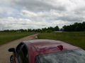
The expedition vehicle, pulled off the road.
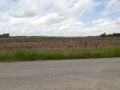
The hashpoint is in the grass just beyond the edge of the gravel.
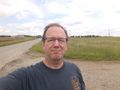
Better than average triumphant picture.


Achievements
- My first expedition to Indiana!