Difference between revisions of "2022-05-22 -43 172"
Quaternary (talk | contribs) (Created page with "{{subst:Expedition |lat = -43 |lon = 172 |date = 2022-05-22 }}") |
Quaternary (talk | contribs) |
||
| Line 1: | Line 1: | ||
| − | + | [[Image:{{{image|2022_05_22_-43_172_01.JPG}}}|thumb|left]] | |
| − | + | <!-- | |
| − | + | And DON'T FORGET to add your expedition and the best photo you took to the gallery on the Main Page! We'd love to read your report, but that means we first have to discover it! :) | |
| − | + | --> | |
| − | |||
| − | + | {{meetup graticule | |
| − | |||
| lat=-43 | | lat=-43 | ||
| lon=172 | | lon=172 | ||
| date=2022-05-22 | | date=2022-05-22 | ||
| − | }} | + | | graticule_name=Christchurch |
| + | | graticule_link=Christchurch,_New_Zealand}} | ||
| + | |||
__NOTOC__ | __NOTOC__ | ||
| + | |||
== Location == | == Location == | ||
| − | + | ||
| + | Fendalton Park, Christchurch, New Zealand | ||
== Participants == | == Participants == | ||
| − | + | ||
| − | + | The [[User:Quaternary|Quaternary]] ([[User talk:Quaternary|talk]]) family geohashers | |
== Plans == | == Plans == | ||
| − | + | ||
| + | A Geohash in a nearby park, and we have friends staying with us from out of town - what a perfect combination of visiting a park plus introducing them to the wonderful pasttime of geohashing! | ||
== Expedition == | == Expedition == | ||
| − | + | ||
| + | It was a pretty easy to locate the hash at the edge of the park which was duley photographed. | ||
| + | |||
| + | However, there was a discussion that there was a possibility that the hash was on the other edge of the boundary fence ... so in order to elimate any question of uncertainty or ambiguity, we lept the fence to the other side - well actually, we just walked up the driveway that was on the other side of the fence, and it turned out there was a convienient gap in the fence that was very handy to walk through. | ||
== Tracklog == | == Tracklog == | ||
| − | < | + | |
| + | <gallery widths="213px" heights="379px" perrow="4"> | ||
| + | Image:2022_05_22_-43_172_Geolocation1.JPG | | ||
| + | Image:2022_05_22_-43_172_Geolocation2.JPG | | ||
| + | Image:2022_05_22_-43_172_Geolocation3.JPG | | ||
| + | Image:2022_05_22_-43_172_Geolocation4.JPG | | ||
| + | </gallery> | ||
== Photos == | == Photos == | ||
| − | < | + | |
| − | Image: | + | <gallery widths="320px" heights="213px" perrow="3"> |
| − | - | + | Image:2022_05_22_-43_172_01.JPG | At the hash, we created what is known as a "hash circle", and hence the saying "many hands make light hash". |
| − | + | Image:2022_05_22_-43_172_02.JPG | Looking east from the hashpoint | |
| + | Image:2022_05_22_-43_172_03.JPG | Looking south from the hashpoint | ||
| + | Image:2022_05_22_-43_172_04.JPG | Looking north from the hashpoint | ||
| + | Image:2022_05_22_-43_172_05.JPG | The other side of the fence from the "hash circle" | ||
| + | Image:2022_05_22_-43_172_06.JPG | The owners of the driveway - thank you for having us | ||
</gallery> | </gallery> | ||
== Achievements == | == Achievements == | ||
| − | |||
| − | |||
| − | + | {{gratuitous ribbon | |
| − | + | | color = red | |
| − | + | | icon = Electric_car.png | |
| + | | latitude = -43 | ||
| + | | longitude = 172 | ||
| + | | date = 2022-05-22 | ||
| + | | achievement = Electric Vehicle Achievement | ||
| + | | description = travelling to and from the Geohash in an electric vehicle | ||
| + | | name = Quaternary | ||
| + | | image = 2014_08_14_-43_172_5_Eco_power.JPG | ||
| + | }} | ||
| − | + | {{drag-along | |
| + | | latitude = -43 | ||
| + | | longitude = 172 | ||
| + | | date = 2022-05-22 | ||
| + | | name = Quaternary | ||
| + | | partner = The Adams family! | ||
| + | | image = 2014_09_16_-43_172_01.JPG | ||
| + | }} | ||
| − | + | ||
| − | |||
| − | |||
| − | |||
| − | |||
| − | |||
| − | |||
| − | |||
[[Category:Expeditions]] | [[Category:Expeditions]] | ||
| − | |||
[[Category:Expeditions with photos]] | [[Category:Expeditions with photos]] | ||
| − | |||
| − | |||
| − | |||
| − | |||
| − | |||
[[Category:Coordinates reached]] | [[Category:Coordinates reached]] | ||
| − | + | [[Category:Meetup on 2022-05-22]] | |
| − | + | [[Category:New report]] | |
| − | |||
| − | |||
| − | |||
| − | |||
| − | |||
| − | |||
| − | |||
| − | [[Category: | ||
| − | |||
| − | |||
| − | |||
| − | |||
| − | |||
| − | [[Category: | ||
| − | |||
| − | |||
Revision as of 06:57, 31 May 2022

| Sun 22 May 2022 in Christchurch: -43.5192826, 172.5915796 geohashing.info google osm bing/os kml crox |
Location
Fendalton Park, Christchurch, New Zealand
Participants
The Quaternary (talk) family geohashers
Plans
A Geohash in a nearby park, and we have friends staying with us from out of town - what a perfect combination of visiting a park plus introducing them to the wonderful pasttime of geohashing!
Expedition
It was a pretty easy to locate the hash at the edge of the park which was duley photographed.
However, there was a discussion that there was a possibility that the hash was on the other edge of the boundary fence ... so in order to elimate any question of uncertainty or ambiguity, we lept the fence to the other side - well actually, we just walked up the driveway that was on the other side of the fence, and it turned out there was a convienient gap in the fence that was very handy to walk through.
Tracklog


Photos
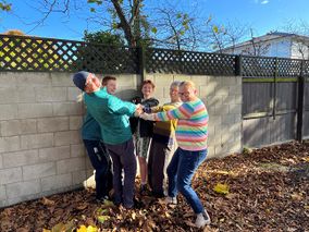
At the hash, we created what is known as a "hash circle", and hence the saying "many hands make light hash".
Looking east from the hashpoint
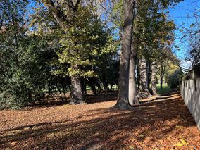
Looking south from the hashpoint
Looking north from the hashpoint
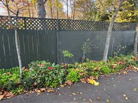
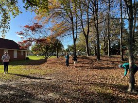
The other side of the fence from the "hash circle"
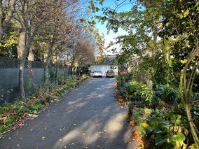
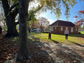
The owners of the driveway - thank you for having us


Achievements
Quaternary earned the Electric Vehicle Achievement
|
Quaternary earned the Drag-along achievement
|