Difference between revisions of "2022-07-06 47 -121"
Michael5000 (talk | contribs) (→Location) |
Michael5000 (talk | contribs) |
||
| Line 1: | Line 1: | ||
| − | + | {{meetup graticule | |
| − | |||
| − | |||
| − | |||
| − | |||
| − | |||
| − | |||
| − | |||
| − | |||
| lat={{#explode:{{SUBPAGENAME}}| |1}} | | lat={{#explode:{{SUBPAGENAME}}| |1}} | ||
| lon={{#explode:{{SUBPAGENAME}}| |2}} | | lon={{#explode:{{SUBPAGENAME}}| |2}} | ||
| Line 15: | Line 7: | ||
== Location == | == Location == | ||
| − | Off I-90 near the | + | Off I-90 near the Kachess Dam. |
== Participants == | == Participants == | ||
| − | |||
| − | |||
| − | + | *[[User:Michael5000|Michael5000]] | |
| − | + | *[[User:Mrs.5000|Mrs.5000]] | |
== Expedition == | == Expedition == | ||
| − | |||
| − | + | From [[2022-07-06 47 -122]], we hopped back on Highway 18, got snarled in traffic on a "quick stop" for gasoline and coffee, and then got rolling again and eastbound on I-90. | |
| − | + | ||
| + | There isn't much lowland between Seattle and the Cascade Mountains, so we started uphill into the forest pretty immediately. It's a beautiful road, really, and I haven't often had reason to drive it, so it definitely constituted a nice drive in the country. To get to the hashpoint we had to overshoot a little, then backtrack a mile or so from the nearest exit, and then drive a short stretch down the Kachess Dam Road. Things looked a little grim for a moment, as we could see from the car that there was a steep plunge from the road into a pond, but happily the hashpoint wasn't down there. We were able to walk a few minutes through the damp forest to a little hill that our three GPS units eventually agreed was the place to be. It was a lovely forest environment, strangely noisy from freight traffic on the nearby interstate. | ||
| + | |||
| + | We continued on towards [[2022-07-06 46 -119]]. | ||
== Photos == | == Photos == | ||
| − | + | ||
| − | |||
| − | |||
<gallery perrow="5"> | <gallery perrow="5"> | ||
| + | File:2022-07-06 47 -121 a.jpg|View from the hashpoint, showing the sunken pond | ||
| + | File:2022-07-06 47 -121 b.jpg|The 5000s atop the hashpoint | ||
| + | File:2022-07-06 47 -121 c.jpg|Looking up from the hashpoint | ||
| + | File:2022-07-06 47 -121 d.jpg|Mrs.5000 returns to the vehicle | ||
</gallery> | </gallery> | ||
| + | |||
== Achievements == | == Achievements == | ||
{{#vardefine:ribbonwidth|800px}} | {{#vardefine:ribbonwidth|800px}} | ||
| − | |||
| − | |||
| − | |||
| − | |||
| − | |||
| − | |||
| − | |||
| − | |||
| − | |||
| − | |||
| − | |||
| − | |||
| − | |||
| − | |||
| − | |||
| − | |||
[[Category:Expeditions]] | [[Category:Expeditions]] | ||
| − | |||
| − | |||
| − | |||
| − | |||
| − | |||
| − | |||
| − | |||
[[Category:Coordinates reached]] | [[Category:Coordinates reached]] | ||
| − | + | *First Expedition to the Snoqualmie graticule for Mrs.5000. | |
| − | + | *First Expedition to Kittatas County for both of us. | |
| − | |||
| − | |||
| − | |||
| − | |||
| − | |||
| − | |||
| − | |||
| − | |||
| − | |||
| − | |||
| − | |||
| − | |||
| − | |||
| − | |||
| − | |||
| − | |||
Revision as of 00:41, 8 July 2022
| Wed 6 Jul 2022 in 47,-121: 47.2593220, -121.1964760 geohashing.info google osm bing/os kml crox |
Location
Off I-90 near the Kachess Dam.
Participants
Expedition
From 2022-07-06 47 -122, we hopped back on Highway 18, got snarled in traffic on a "quick stop" for gasoline and coffee, and then got rolling again and eastbound on I-90.
There isn't much lowland between Seattle and the Cascade Mountains, so we started uphill into the forest pretty immediately. It's a beautiful road, really, and I haven't often had reason to drive it, so it definitely constituted a nice drive in the country. To get to the hashpoint we had to overshoot a little, then backtrack a mile or so from the nearest exit, and then drive a short stretch down the Kachess Dam Road. Things looked a little grim for a moment, as we could see from the car that there was a steep plunge from the road into a pond, but happily the hashpoint wasn't down there. We were able to walk a few minutes through the damp forest to a little hill that our three GPS units eventually agreed was the place to be. It was a lovely forest environment, strangely noisy from freight traffic on the nearby interstate.
We continued on towards 2022-07-06 46 -119.
Photos
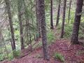
View from the hashpoint, showing the sunken pond

The 5000s atop the hashpoint
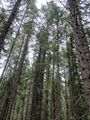
Looking up from the hashpoint
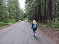
Mrs.5000 returns to the vehicle


Achievements
- First Expedition to the Snoqualmie graticule for Mrs.5000.
- First Expedition to Kittatas County for both of us.