Difference between revisions of "2018-08-29 52 9"
From Geohashing
m (user categories) |
m (Adding hours) |
||
| Line 39: | Line 39: | ||
[[Category:Expeditions with photos]] | [[Category:Expeditions with photos]] | ||
{{location|DE|NI|NI}} | {{location|DE|NI|NI}} | ||
| − | {{user categories|user=Fippe|tram=21|train=111|foot=9}} | + | {{user categories|user=Fippe|tram=21|train=111|foot=9|hours=14}} |
Latest revision as of 19:09, 11 December 2022
| Wed 29 Aug 2018 in Hannover: 52.6309156, 9.1829821 geohashing.info google osm bing/os kml crox |
Location
This Geohash is located on a field near Nienburg.
Participants
Expedition
I took the train to Nienburg and walked to the geohash from there. Nienburg is on the river Weser, and has a nice Old City, both of which I saw on the expedition. I also walked through a path which had lot's of apple trees.
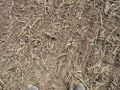
This geohash was located about 50 meters from the edge of a harvested field, so I could reach the coordinates. There is a hydrant next to the field, which I added to OpenStreetMap.
Photos

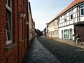
Nienburg's Old City
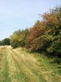
The path to this Geohash
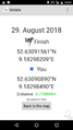
Proof
This Geohash
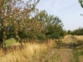
Apple trees


Achievements
Fippe earned the Land geohash achievement
|
Fippe earned the OpenStreetMap achievement
|