Difference between revisions of "2022-04-05 52 10"
From Geohashing
(→Ribbons: last man standing) |
m (Adding hours) |
||
| Line 30: | Line 30: | ||
[[Category:Expeditions with photos]] | [[Category:Expeditions with photos]] | ||
{{location|DE|NI|H}} | {{location|DE|NI|H}} | ||
| − | {{user categories|user=Fippe|bike=42}} | + | {{user categories|user=Fippe|bike=42|hours=19}} |
Latest revision as of 19:53, 11 December 2022
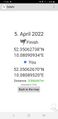
| Tue 5 Apr 2022 in 52,10: 52.3506274, 10.0809093 geohashing.info google osm bing/os kml crox |
Location
This Geohash is located in the eponymous forest of Hämelerwald.
Participants
Expedition
Cycled there, reached the coordinates. It rained.
Photos

Proof
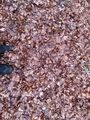
The Geohash
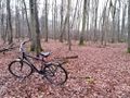
The site of the Geohash with my bicycle


Ribbons
Fippe earned the Land geohash achievement
|
Fippe earned the Bicycle geohash achievement
|
Fippe earned the Drowned Rat Geohash Achievement
|
Fippe earned the OpenStreetMap achievement
|
Fippe earned the Last man standing achievement
|