Difference between revisions of "2022-06-30 52 9"
From Geohashing
(new report) |
m (Adding hours) |
||
| Line 31: | Line 31: | ||
[[Category:Expeditions with photos]] | [[Category:Expeditions with photos]] | ||
{{location|DE|NI|H}} | {{location|DE|NI|H}} | ||
| − | {{user categories|user=Fippe|bike=14}} | + | {{user categories|user=Fippe|bike=14|hours=06}} |
Latest revision as of 20:01, 11 December 2022
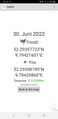
| Thu 30 Jun 2022 in 52,9: 52.2939772, 9.7942160 geohashing.info google osm bing/os kml crox |
Location
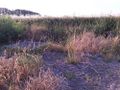
This Geohash is located in an infiltration basin in Pattensen.
Participants
Expedition
In the morning I cycled to Laatzen. The basin looked full on satellite images, so I had a towel with me in case I would need to swim. That was not necessary as the basin was completely dried out. After locating the coordinates in the basin, I cycled back home.
Photos

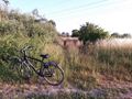
My bicycle near the coordinates
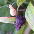
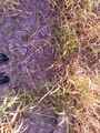
A toad and a snail
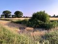
The site of the Geohash
Proof
The Geohash
In the basin


Ribbons
Fippe earned the Land geohash achievement
|
Fippe earned the Bicycle geohash achievement
|
Fippe earned the OpenStreetMap achievement
|