Difference between revisions of "2023-04-02 42 2"
(Expedition report.) |
(Pictures!) |
||
| Line 12: | Line 12: | ||
== Plans == | == Plans == | ||
| − | Take the train to Sant Quirze de | + | Take the train to Sant Quirze de Besora, hike to the hash, and back to Sant Quirze de Besora. |
== Expedition == | == Expedition == | ||
| − | Went as planned. Took the train to Sant Quirze de | + | Went as planned. Took the train to Sant Quirze de Besora from Barcelona, which is the last station on this line that I can go with my ''monthly'' ticket. At 11h I was there ready to start my hike which was short of 30km. It ended being 28km. |
At the very beginning I found that one of the paths I wanted to take was fenced. On this area not all the paths are on google maps or OSM or similar. So I kind of improvised, going in the general direction I wanted to go until I found some not-mapped-path that took me to my original track. This was the only difficulty I found. | At the very beginning I found that one of the paths I wanted to take was fenced. On this area not all the paths are on google maps or OSM or similar. So I kind of improvised, going in the general direction I wanted to go until I found some not-mapped-path that took me to my original track. This was the only difficulty I found. | ||
| Line 31: | Line 31: | ||
== Photos == | == Photos == | ||
| − | |||
| − | |||
<gallery mode=packed heights=225px> | <gallery mode=packed heights=225px> | ||
| − | File: | + | File:2023-04-02 42 2 stquirze.JPG|At Sant Quirze de Besora. |
| + | File:2023-04-02 42 2 stquirze2.JPG|Leaving Sant Quirze. | ||
| + | File:2023-04-02 42 2 sora.JPG|In Sora, where I had lunch. | ||
| + | File:2023-04-02 42 2 geohash1.JPG|Approaching the geohash. | ||
| + | File:2023-04-02 42 2 geohash2.JPG|Sharing the geohash with some cows. | ||
| + | File:2023-04-02 42 2 GPSr.jpg|Proof with GPSr. | ||
| + | File:2023-04-02 42 2 geohash3.JPG|Geohash seen from the road. | ||
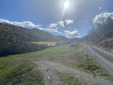
| + | File:2023-04-02 42 2 view_sora.JPG|View from els Munts. Can you see Sora, where I had lunch, the village down there on the left? | ||
| + | File:2023-04-02 42 2 panoramic.JPG|Panoramic view from els Munts. | ||
| + | File:2023-04-02 42 2 valley.JPG|Way back to Sant Quirze. | ||
| + | File:2023-04-02 42 2 back.JPG|Looking back at the sanctuary. Can you see it up there? | ||
</gallery> | </gallery> | ||
| − | |||
== Achievements == | == Achievements == | ||
Revision as of 19:15, 3 April 2023
| Sun 2 Apr 2023 in 42,2: 42.1058775, 2.1267425 geohashing.info google osm bing/os kml crox |
Location
On the road between Alpens and Sant Agustí de Lluçanès, on the natural county Lluçanès.
Participants
Plans
Take the train to Sant Quirze de Besora, hike to the hash, and back to Sant Quirze de Besora.
Expedition
Went as planned. Took the train to Sant Quirze de Besora from Barcelona, which is the last station on this line that I can go with my monthly ticket. At 11h I was there ready to start my hike which was short of 30km. It ended being 28km.
At the very beginning I found that one of the paths I wanted to take was fenced. On this area not all the paths are on google maps or OSM or similar. So I kind of improvised, going in the general direction I wanted to go until I found some not-mapped-path that took me to my original track. This was the only difficulty I found.
The other one was the distance. Might have been a little bit too long from what I had planned. Had I started earlier might have been alright. Nothing I can do now.
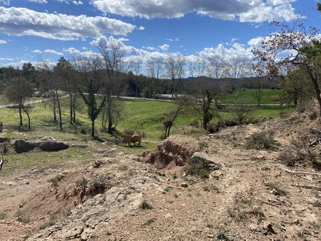
Had lunch in Sora and then I was ready to approach the hash. It was near the road. I enjoyed the company of some cows drinking water on the hash area. This is the first hash on the Catalan side of the 42,2 graticule, so yay!
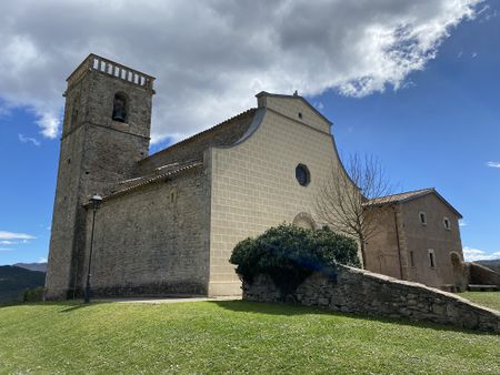
After that I went to the Sanctuary dels Munts at the top of the nearby mountain at 1000m. From here I had fantastic 360º views: from Montserrat, to the Cadi mountain range (and the iconic Pedraforca), to the Pyrenees. Breathtaking. Really worth making the distance to get here.
Once up there I realized the train I wanted to take was parting in ~1:30h and I hadn't enough time to make the 8-9 kilometres that were ahead of me. I was in no condition to walk fast. So I took the decision to take it slow, take the next train, and although I would arrive late at home it was ultimately best.
Tracklog
Photos
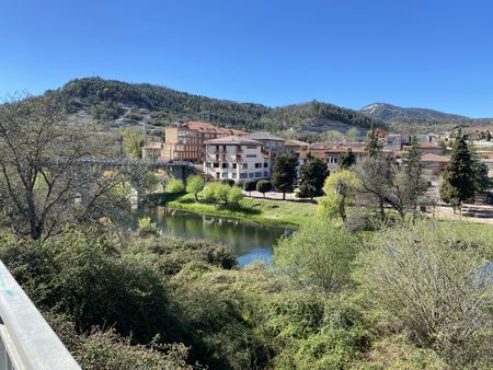
At Sant Quirze de Besora.
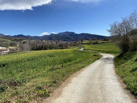
Leaving Sant Quirze.
In Sora, where I had lunch.
Approaching the geohash.
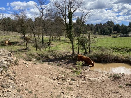
Sharing the geohash with some cows.
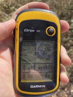
Proof with GPSr.
Geohash seen from the road.
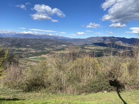
View from els Munts. Can you see Sora, where I had lunch, the village down there on the left?
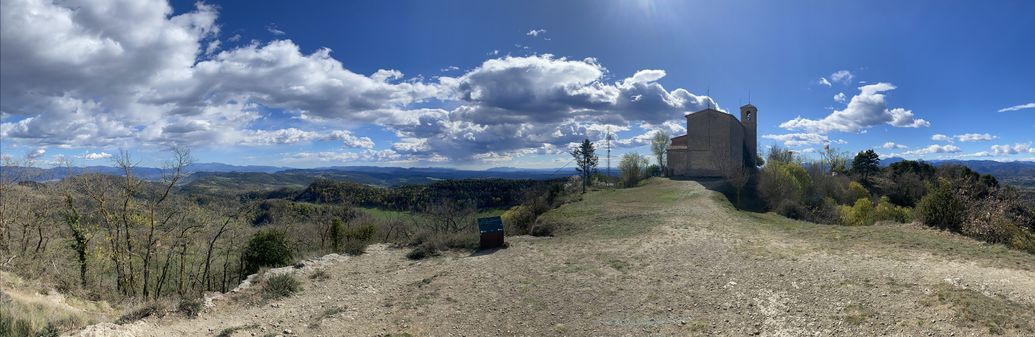
Panoramic view from els Munts.
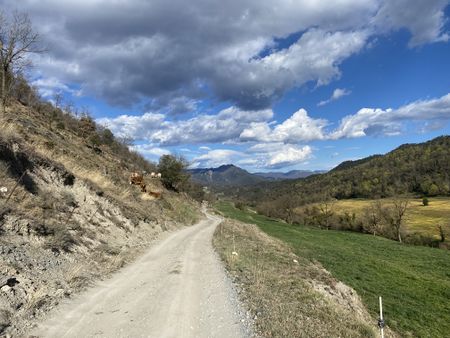
Way back to Sant Quirze.
Looking back at the sanctuary. Can you see it up there?


Achievements
SastRe.O achieved level 4 of the Minesweeper Geohash achievement
|
SastRe.O achieved level 4 of the Minesweeper Geohash achievement
|
SastRe.O achieved level 4 of the Minesweeper Geohash achievement
|
SastRe.O achieved level 4 of the Minesweeper Geohash achievement
|
SastRe.O achieved level 2 of the Minesweeper Geohash achievement
|
Other Geohashing Expeditions and Plans on This Day
Expeditions and Plans
| 2023-04-02 | ||
|---|---|---|
| Perpignan, France | SastRe.O | On the road between Alpens and Sant Agustí de Lluçanès, on the natural coun... |
| Braunschweig, Germany | Fippe | located on the edge of a narrow field in Astenbeck. |