Difference between revisions of "2023-09-10 -45 170"
m (Location) |
(Categories) |
||
| Line 1: | Line 1: | ||
| − | |||
| − | |||
| − | |||
| − | |||
| − | |||
| − | |||
| − | |||
| − | |||
| − | |||
| − | |||
{{meetup graticule | {{meetup graticule | ||
| lat=-45 | | lat=-45 | ||
| Line 36: | Line 26: | ||
Headed back and got another bus and arrived back home, safe and sound. | Headed back and got another bus and arrived back home, safe and sound. | ||
| − | |||
== Photos == | == Photos == | ||
| Line 58: | Line 47: | ||
}} | }} | ||
| − | |||
| − | |||
| − | |||
| − | |||
| − | |||
| − | |||
| − | |||
| − | |||
| − | |||
| − | |||
[[Category:Expeditions]] | [[Category:Expeditions]] | ||
| − | |||
[[Category:Expeditions with photos]] | [[Category:Expeditions with photos]] | ||
| − | |||
| − | |||
| − | |||
| − | |||
| − | |||
[[Category:Coordinates reached]] | [[Category:Coordinates reached]] | ||
| − | |||
| − | |||
{{location|NZ|OTA}} | {{location|NZ|OTA}} | ||
Latest revision as of 09:04, 10 September 2023
| Sun 10 Sep 2023 in -45,170: -45.9013268, 170.4588536 geohashing.info google osm bing/os kml crox |
Location
On an offramp from a motorway.
Participants
Plans
Take a bus close as I can and walk the rest of the way. Hope it on the footpath and I don't have to jump a fence give up my attempt.
Expedition
I wanted to go around 11:30am. However, the curse of being on-call made someone call me at 11:24am. After a large string of expletives after I got off the phone, I had to deal with the on-call issue.
Over 3 hours later, I hopped on a 3:30pm bus and headed off. The driver got a radio that a passenger on a bus on the same route had lost their key (singular). Helped him look for it but to no avail.
Hopped off 6km later and walked the rest of the way to the hash. Fairly uneventful but it was near a church with an erected cross on the hill, so I hoped to take a photo of that. Alas, it was on the concealed side.
Photos taken, proof made, no marker left unfortunately. Maybe next time.
Headed back and got another bus and arrived back home, safe and sound.
Photos
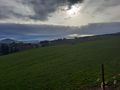
Alas, no cross, but just more hills and fields
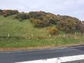
What behind me looked like. Thank god it wasn't 20 meters to the left.
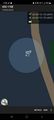
Proof 1

Proof 2


Achievements
AscendingAnthem earned the Land geohash achievement
|