Difference between revisions of "2023-09-17 39 -77"
Michael5000 (talk | contribs) (→Participants) |
Michael5000 (talk | contribs) |
||
| Line 18: | Line 18: | ||
*[[user:Michael5000|Michael5000]] | *[[user:Michael5000|Michael5000]] | ||
| − | == | + | == Expedition == |
| − | + | After a Saturday of doing Washington D.C. things in Washington D.C., on Sunday I drove through the wilds of northern Virginia and into West Virginia, up to Martinsburg. It seemed like a fairly bustling town, but what do I know. I went to their City National Bank, took a few pictures, stopped by their Dunkin Donuts, and moved on. | |
| − | + | It was my first geohash in West Virginia, and the little round trip got me to four new counties, so that was good. | |
| − | |||
| − | + | About nine miles east is a tiny little college town called Shepherdstown, with a nice little book shop where I bought a few books and a nice little bike rental shop where I rented a bike. Over the bridge in Maryland is the old Chesapeake and Ohio Trail, which is a lovely little tunnel through the woods next to the Potomac River. It was raining pretty steadily for much of the ride, but the trees were thick enough that I stayed relatively dryish. | |
| − | |||
== Photos == | == Photos == | ||
| − | |||
| − | |||
| − | |||
<gallery perrow="5"> | <gallery perrow="5"> | ||
| + | File:2023-09-17 39 -77 a.jpg|The Berkeley County Courthouse. Not close to the hashpoint, but a nice local landmark. | ||
| + | File:2023-09-17 39 -77 b.jpg|Looking north from the hashpoint, at an Arby's. | ||
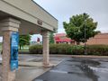
| + | File:2023-09-17 39 -77 c.jpg|Looking east from the hashpoint, at apartments. | ||
| + | File:2023-09-17 39 -77 d.jpg|Me, at the hashpoint. | ||
| + | File:2023-09-17 39 -77 e.jpg|Mascot hijinks. | ||
| + | File:2023-09-17 39 -77 f.jpg|The rental expedition vehicle. | ||
| + | File:2023-09-17 39 -77 g.jpg|The Chesapeake and Ohio Trail. | ||
</gallery> | </gallery> | ||
| Line 39: | Line 41: | ||
__NOTOC__ | __NOTOC__ | ||
| − | |||
| − | |||
| − | |||
| − | |||
| − | |||
| − | |||
| − | |||
| − | |||
| − | |||
| − | |||
| − | |||
| − | |||
| − | |||
| − | |||
[[Category:Expeditions]] | [[Category:Expeditions]] | ||
| − | |||
[[Category:Expeditions with photos]] | [[Category:Expeditions with photos]] | ||
| − | |||
| − | |||
| − | |||
| − | |||
| − | |||
[[Category:Coordinates reached]] | [[Category:Coordinates reached]] | ||
| − | |||
| − | |||
| − | |||
| − | |||
| − | |||
| − | |||
| − | |||
| − | |||
| − | |||
| − | |||
| − | |||
| − | |||
| − | |||
| − | |||
| − | |||
| − | |||
| − | |||
| − | |||
Revision as of 22:36, 17 September 2023
| Sun 17 Sep 2023 in 39,-77: 39.4811939, -77.9573107 geohashing.info google osm bing/os kml crox |
Location
A drive-thru lane at a bank in Martinsburg, West Virgnina
Participants
Expedition
After a Saturday of doing Washington D.C. things in Washington D.C., on Sunday I drove through the wilds of northern Virginia and into West Virginia, up to Martinsburg. It seemed like a fairly bustling town, but what do I know. I went to their City National Bank, took a few pictures, stopped by their Dunkin Donuts, and moved on.
It was my first geohash in West Virginia, and the little round trip got me to four new counties, so that was good.
About nine miles east is a tiny little college town called Shepherdstown, with a nice little book shop where I bought a few books and a nice little bike rental shop where I rented a bike. Over the bridge in Maryland is the old Chesapeake and Ohio Trail, which is a lovely little tunnel through the woods next to the Potomac River. It was raining pretty steadily for much of the ride, but the trees were thick enough that I stayed relatively dryish.
Photos
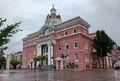
The Berkeley County Courthouse. Not close to the hashpoint, but a nice local landmark.
Looking north from the hashpoint, at an Arby's.
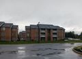
Looking east from the hashpoint, at apartments.

Me, at the hashpoint.
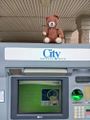
Mascot hijinks.
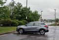
The rental expedition vehicle.
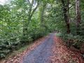
The Chesapeake and Ohio Trail.


