Difference between revisions of "2023-10-12 37 -113"
Michael5000 (talk | contribs) (→Achievements) |
Michael5000 (talk | contribs) (→Achievements) |
||
| Line 39: | Line 39: | ||
__NOTOC__ | __NOTOC__ | ||
| − | |||
| − | |||
| − | |||
| − | |||
| − | |||
| − | |||
| − | |||
| − | |||
| − | |||
| − | |||
| − | |||
| − | |||
| − | |||
[[Category:Expeditions]] | [[Category:Expeditions]] | ||
| − | |||
[[Category:Expeditions with photos]] | [[Category:Expeditions with photos]] | ||
| − | |||
| − | |||
| − | |||
| − | |||
| − | |||
[[Category:Coordinates reached]] | [[Category:Coordinates reached]] | ||
| − | |||
| − | |||
| − | |||
| − | |||
| − | |||
| − | |||
| − | |||
| − | |||
| − | |||
| − | |||
| − | |||
| − | |||
| − | |||
| − | |||
| − | |||
| − | |||
| − | |||
| − | |||
Revision as of 04:53, 13 October 2023
| Thu 12 Oct 2023 in 37,-113: 37.0965110, -113.4116425 geohashing.info google osm bing/os kml crox |
Location
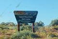
In the Sand Mountain OHV Area, east of St George.
Participants
Expedition
For two and a half days, I attended to the business end of the business-and-adventure trip, then reclaimed the Expedition Vehicle from the conference hotel parking garage and headed northeast towards this hashpoint.
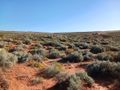
I've just looked up "OHV," and it stands for "Off-Highway Vehicles" -- dune buggies, in other words. Why do they call it Sand Mountain? Well, for the obvious reason, as it turns out. The sand in question is a kind of orange-pink color, with a moderate cover of desert plants and the occasional cactus, making this a distinctive and pretty place to take a walk. Or, I suppose, to drive a dune buggy.
It was about a kilometer from the parking area to the hashpoint, but felt a little longer than that because walking on sand is a little effortful. But, it wasn't anything I couldn't handle. I headed back to the vehicle and pointed its nose one degree of latitude north.
Photos
I didn't bring an OHV
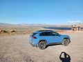
Nice view from the parking lot
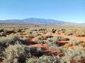
Looking north from the hashpoint
Looking south from the hashpoint
The hashpoint

Me, at the hashpoint


