Difference between revisions of "2023-10-17 49 11"
([live picture]View from hash) |
|||
| Line 14: | Line 14: | ||
== Location == | == Location == | ||
<!-- where you've surveyed the hash to be --> | <!-- where you've surveyed the hash to be --> | ||
| + | In the woods close to Finstermühle | ||
== Participants == | == Participants == | ||
<!-- who attended: If you link to your wiki user name in this section, your expedition will be picked up by the various statistics generated for geohashing. You may use three tildes ~ as a shortcut to automatically insert the user signature of the account you are editing with. | <!-- who attended: If you link to your wiki user name in this section, your expedition will be picked up by the various statistics generated for geohashing. You may use three tildes ~ as a shortcut to automatically insert the user signature of the account you are editing with. | ||
--> | --> | ||
| + | [[User:Torodeas|Torodeas]] ([[User talk:Torodeas|talk]]) | ||
| − | == | + | == Expedition == |
| − | + | I've been waiting for a hash like this: | |
| + | Reachable by foot from the Allersberg train station, | ||
| + | giving me an excuse to take one of the strangest trains in Nuremberg's train network: | ||
| + | A regional train that starts in Nuremberg Central and follows the high speed line from Nuremberg to Ingolstadt - | ||
| + | for exactly one stop, until Allersberg, where it terminates. The whole line has just these two stops. | ||
| + | |||
| + | But sadly, this hash isn't ideal. It is reachable from Allersberg, but winter is rapidly approaching | ||
| + | and so the days of unlimited sunlight are gone. | ||
| + | If I go for the hash after work, with more than one hour to walk from Allersberg to the hash, It'll be quite dark at the hash, | ||
| + | and even worse on my way back to the station. | ||
| + | |||
| + | I choose another approach: The hash is much closer to the bus stop Finstermühle than to Allersberg train station. | ||
| + | And there is a bus-like thing that can get me there - or might pick me up there. | ||
| + | Taking the train to Allersberg, walking to the hash and catch the bus home doesn't work, | ||
| + | because this bus is special: Even though it is a regularly scheduled service, you need to call in advance, announcing your intend to travel. | ||
| + | I find it very hard to judge how long I need to walk until I arrive, and how long I might be searching for the hash. | ||
| + | And it'll still be dark once I'm at the hash, making pictures less pretty. | ||
| − | + | So I do it the other way: I take the bus to Finstermühle, using the piece of track that hash carried me to [[2023-08-25_48_11]], [[2023-10-03_48_10]], and [[2023-10-05_49_11]] from Nuremberg Central southbound, | |
| − | + | and walk over to Allersberg after I'm done. | |
| + | |||
| + | I reach Finstermühle without issues and on time, | ||
| + | and get to search for the hash with decent lighting. | ||
| + | The hash is a piece of forest, and has no path I can follow until I'm close, | ||
| + | so I appreaciate the additional light while I meter for meter search my way through the forest. | ||
| + | The last 20 meters are tricky without any points of reference, but after some back-and-forth, | ||
| + | I get a very nice reading on my device and record proof. | ||
| + | |||
| + | After that I go back to a designated path and walk over to Allersberg. | ||
| + | I intially navigate just with cardinal directions - and a faint memory that there should be a path all the way through, | ||
| + | even though my digital map - again - fails me and doesn't show all the footpaths in the forest. Online they have everything, | ||
| + | but once you're offline all these footpaths just vanish. | ||
| + | |||
| + | Half way to Allersberg, I get a useful sign telling me I'm on a designated cycling path to Allersberg train station. Great, that's what I was looking for. | ||
| + | With more confidence, I follow the path and arrive at said train station - even a bit ahead of schedule. | ||
| + | |||
| + | Me arriving earlier than expected is great - It allows me to arrive home earlier - but sadly, this earlier connection does not use the special train I was hoping for. | ||
| + | Instead, I get on the much more reasonable medium-distance (but still regional) train connecting Nuremberg and Munich. A train I have used quite frequently. | ||
| + | There will be other hashes I can explore from Allersberg, and one time I will be able to take the special train line that just connects Allersberg and Nuremberg. | ||
== Tracklog == | == Tracklog == | ||
| Line 44: | Line 81: | ||
{{#vardefine:ribbonwidth|100%}} | {{#vardefine:ribbonwidth|100%}} | ||
<!-- Add any achievement ribbons you earned below, or remove this section --> | <!-- Add any achievement ribbons you earned below, or remove this section --> | ||
| + | {{land geohash | ||
| + | | date = 2023-10-17 | ||
| + | | latitude = 49 | ||
| + | | longitude = 11 | ||
| + | | name = [[User:Torodeas|Torodeas]] ([[User talk:Torodeas|talk]]) | ||
| + | }} | ||
| + | |||
| + | {{Public transport geohash | ||
| + | | date = 2023-10-17 | ||
| + | | latitude = 49 | ||
| + | | longitude = 11 | ||
| + | | name = [[User:Torodeas|Torodeas]] ([[User talk:Torodeas|talk]]) | ||
| + | | busline = 199, 4, U1, RE16, 680.3 | ||
| + | }} | ||
__NOTOC__ | __NOTOC__ | ||
<!-- =============== USEFUL CATEGORIES FOLLOW ================ | <!-- =============== USEFUL CATEGORIES FOLLOW ================ | ||
Delete the next line ONLY if you have chosen the appropriate categories below. If you are unsure, don't worry. People will read your report and help you with the classification. --> | Delete the next line ONLY if you have chosen the appropriate categories below. If you are unsure, don't worry. People will read your report and help you with the classification. --> | ||
| − | [[Category: | + | |
| + | |||
| + | [[Category:Expeditions]] | ||
| + | |||
| + | [[Category:Expeditions with photos]] | ||
| + | |||
| + | [[Category:Coordinates reached]] | ||
<!-- ==REQUEST FOR TWITTER BOT== Please leave either the New report or the Expedition planning category in as long as you work on it. This helps the twitter bot a lot with announcing the right outcome at the right moment. --> | <!-- ==REQUEST FOR TWITTER BOT== Please leave either the New report or the Expedition planning category in as long as you work on it. This helps the twitter bot a lot with announcing the right outcome at the right moment. --> | ||
Revision as of 18:11, 17 October 2023
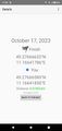
| Tue 17 Oct 2023 in 49,11: 49.2766663, 11.1664179 geohashing.info google osm bing/os kml crox |
Location
In the woods close to Finstermühle
Participants
Expedition
I've been waiting for a hash like this: Reachable by foot from the Allersberg train station, giving me an excuse to take one of the strangest trains in Nuremberg's train network: A regional train that starts in Nuremberg Central and follows the high speed line from Nuremberg to Ingolstadt - for exactly one stop, until Allersberg, where it terminates. The whole line has just these two stops.
But sadly, this hash isn't ideal. It is reachable from Allersberg, but winter is rapidly approaching and so the days of unlimited sunlight are gone. If I go for the hash after work, with more than one hour to walk from Allersberg to the hash, It'll be quite dark at the hash, and even worse on my way back to the station.
I choose another approach: The hash is much closer to the bus stop Finstermühle than to Allersberg train station. And there is a bus-like thing that can get me there - or might pick me up there. Taking the train to Allersberg, walking to the hash and catch the bus home doesn't work, because this bus is special: Even though it is a regularly scheduled service, you need to call in advance, announcing your intend to travel. I find it very hard to judge how long I need to walk until I arrive, and how long I might be searching for the hash. And it'll still be dark once I'm at the hash, making pictures less pretty.
So I do it the other way: I take the bus to Finstermühle, using the piece of track that hash carried me to 2023-08-25_48_11, 2023-10-03_48_10, and 2023-10-05_49_11 from Nuremberg Central southbound, and walk over to Allersberg after I'm done.
I reach Finstermühle without issues and on time, and get to search for the hash with decent lighting. The hash is a piece of forest, and has no path I can follow until I'm close, so I appreaciate the additional light while I meter for meter search my way through the forest. The last 20 meters are tricky without any points of reference, but after some back-and-forth, I get a very nice reading on my device and record proof.
After that I go back to a designated path and walk over to Allersberg. I intially navigate just with cardinal directions - and a faint memory that there should be a path all the way through, even though my digital map - again - fails me and doesn't show all the footpaths in the forest. Online they have everything, but once you're offline all these footpaths just vanish.
Half way to Allersberg, I get a useful sign telling me I'm on a designated cycling path to Allersberg train station. Great, that's what I was looking for. With more confidence, I follow the path and arrive at said train station - even a bit ahead of schedule.
Me arriving earlier than expected is great - It allows me to arrive home earlier - but sadly, this earlier connection does not use the special train I was hoping for. Instead, I get on the much more reasonable medium-distance (but still regional) train connecting Nuremberg and Munich. A train I have used quite frequently. There will be other hashes I can explore from Allersberg, and one time I will be able to take the special train line that just connects Allersberg and Nuremberg.
Tracklog
Photos
Proof
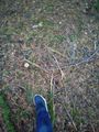
At the hash
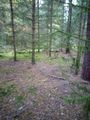
View from hash


Achievements
Torodeas (talk) earned the Land geohash achievement
|
Torodeas (talk) earned the Public transport geohash achievement
|