Difference between revisions of "2023-09-21 51 9"
From Geohashing
(expedition report for Ahnatal) |
m (Location) |
||
| Line 42: | Line 42: | ||
[[Category:Coordinates reached]] | [[Category:Coordinates reached]] | ||
| + | {{location|DE|HE|KS}} | ||
Latest revision as of 10:42, 22 December 2023
| Thu 21 Sep 2023 in 51,9: 51.3785623, 9.4183274 geohashing.info google osm bing/os kml crox |
Location
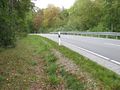
The hash lay on the state road 3217 near Ahnatal.
Participants
Plans
Walking around and looking for the hash.
Expedition
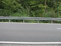
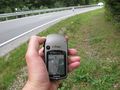
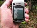
I used a local minibus to come near to the hash and walked along some small paths. I found out that the road was narrow and heavy used and there was no place for a dance. The GPSr showed me I was in the bushes and nine meters away, but I was standing near the white line and the hash should be in the middle of the road. So I thought I was only five meters away. From the other side I could not go nearer as 12 meters.
Tracklog
Photos
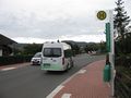
arrived
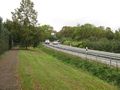
the hash lay on this road some meters uphill

not the sort of proof I like
the road with the hash
looking south
looking north
from the other side


