Difference between revisions of "2024-02-02 49 8"
Green guy! (talk | contribs) (Gallery added, but upload trouble with one specific photo) |
Green guy! (talk | contribs) (Gallery finished and pictures added to templates) |
||
| Line 1: | Line 1: | ||
| − | <!-- | + | <!-- [[File:Geohash 2024-02-02 49 8 looking east 1.jpg|thumb|left]] --> |
| − | + | <!-- | |
| − | [[ | ||
| − | |||
| − | |||
| − | |||
| − | |||
And DON'T FORGET to add your expedition and the best photo you took to the gallery on the Main Page! We'd love to read your report, but that means we first have to discover it! :) | And DON'T FORGET to add your expedition and the best photo you took to the gallery on the Main Page! We'd love to read your report, but that means we first have to discover it! :) | ||
--> | --> | ||
| Line 51: | Line 46: | ||
== Pictures == | == Pictures == | ||
| − | |||
| − | |||
| − | |||
| − | |||
<gallery perrow="5"> | <gallery perrow="5"> | ||
| − | File:Geohash 2024-02-02 49 8 OruxMaps Coordinates.png | + | File:Geohash 2024-02-02 49 8 OruxMaps Coordinates.png | Coordinates reached in OruxMaps |
| − | File:Geohash 2024-02-02 49 8 looking east 1.jpg | + | File:Geohash 2024-02-02 49 8 looking east 1.jpg | Looking east from the hashpoint (our car is on the left) |
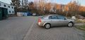
| − | File:Geohash 2024-02-02 49 8 looking west CROPPED.jpg | + | File:Geohash 2024-02-02 49 8 looking west CROPPED.jpg | Looking west into sunset and construction site <small>(had to crop the right half of the image with my parents)</small> |
| − | File:Geohash 2024-02-02 49 8 looking north.jpg | + | File:Geohash 2024-02-02 49 8 looking north.jpg | Looking north from the hashpoint |
| − | File:Geohash 2024-02-02 49 8 looking east 2.jpg | + | File:Geohash 2024-02-02 49 8 looking east 2.jpg | Looking east from the hashpoint (our car is on the right) |
| − | File:Geohash 2024-02-02 49 8 stupid grin 1 EDIT.jpeg | + | File:Geohash 2024-02-02 49 8 stupid grin 1 EDIT.jpeg | Stupidly grinning because I’m joyful about visiting my first geohash |
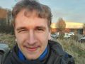
| − | File:Geohash 2024-02-02 49 8 stupid grin 2 EDIT.jpeg | + | File:Geohash 2024-02-02 49 8 stupid grin 2 EDIT.jpeg | Fun fact: Usually, I <em>never</em> take selfies! But geohashing gives me enough reason to do so. |
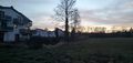
| − | File:Geohash 2024-02-02 49 8 Trip 1 Zahlwaldhalle.jpg | + | File:Geohash 2024-02-02 49 8 Trip 1 Zahlwaldhalle.jpg | ''Zahlwaldhalle'', east of the hashpoint |
| − | File:Geohash 2024-02-02 49 8 Trip 2 Timber.jpg | | + | File:Geohash 2024-02-02 49 8 Trip 2 Timber.jpg | A bunch of timber lying around |
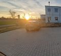
| − | File:Geohash 2024-02-02 49 8 Trip 3 Sunset.jpg | + | File:Geohash 2024-02-02 49 8 Trip 3 Sunset.jpg | A beautiful sunset |
| − | File:Geohash 2024-02-02 49 8 Trip 5.jpg | + | File:Geohash 2024-02-02 49 8 Trip 5.jpg | Sunset view from our car |
| − | File:Geohash 2024-02-02 49 8 Trip 6 Pizza Margherita at Ristorante Tiramisu.jpg | + | File:Geohash 2024-02-02 49 8 Trip 6 Pizza Margherita at Ristorante Tiramisu.jpg | Enjoying a Pizza Margherita at ''Ristorante Tiramisu'' |
</gallery> | </gallery> | ||
| Line 77: | Line 68: | ||
| date = 2024-02-02 | | date = 2024-02-02 | ||
| name = [[User:Green guy!|Green guy!]] ([[User talk:Green guy!|talk]]) | | name = [[User:Green guy!|Green guy!]] ([[User talk:Green guy!|talk]]) | ||
| − | | image = | + | | image = Geohash 2024-02-02 49 8 stupid grin 1 EDIT.jpeg |
}} | }} | ||
{{drag-along | {{drag-along | ||
Revision as of 10:25, 3 February 2024
| Fri 2 Feb 2024 in 49,8: 49.8677017, 8.7621142 geohashing.info google osm bing/os kml crox |
Location
The westernmost of two parking lots that belong to a sports hall called Zahlwaldhalle. This place lies near Roßdorf, Landkreis Darmstadt-Dieburg, Hesse, Germany.
According to Bing Aerial, it’s the fourth parking space on the right when viewing from the entrance.
Participants
- Green guy! (talk)
- Green guy!’s mother (no consent to publish photos of her)
- Green guy!’s father (no consent to publish photos of him)
Plans
As the hashpoint lies right on a public parking lot and because it’s the first one in near vicinity from our home since I discovered geohashing on January 23, I wanted to do a trip there with my parents by car (setting off between 4 pm and 5 pm local time, after my apprenticeship working hours). Even though we probably didn’t even need to leave the car for reaching the hashpoint (which is a not-so-frequent occasion), I wanted to go for a walk in the vicinity since I have a passion to discover and explore new places in the world. After that, we intended to go to a restaurant in the nearby village Roßdorf.
Expedition
(Side note: Is this trip actually worthy to be called an expedition?)
As planned, my parents and I drove to the geohash by car (with my father at the wheel): We took the B26 motorroad (trunk road) headed towards Dieburg, and drove off at the Roßdorf-Ost exit. Then, we turned right a few times to reach the parking lot just before 5 pm.
We were able to park our car exactly on the previously-mentioned fourth parking space on the right. We got out of the car and I snapped some photos and a screenshot of OruxMaps with the coordinates. The parking lot is abbutted by a construction site on the west and the Zahlwaldhalle on the east.
Next, we went for a counter-clockwise walk around the sports center and the Ruhewald Roßdorf graveyard: It wasn’t too cold, but really windy, especially on the open fields. My mother really liked walking on the forest track leading to the graveyard as it was abundantly covered with leaves from the last fall (autumn). When we reached the Ruhewald Roßdorf graveyard, we were somewhat surprised (and my mother accused me of hoodwinking her) of not finding an actual cemetery, but a Bestattungswald (“burial forest”) instead. After that, we walked south and saw a beautiful sunset on the open landscape. Finally, we walked back to our car to go to a restaurant in Roßdorf. At that point, the time was just before 5:30 pm, a time when many restaurants open for dinner.
First, we tried out the popular family-operated restaurant Zur Sonne in the center of Roßdorf – however, we were quickly driven away from this place due to severe stench from tobacco smoke in the corridor that leaked into the dining room. It was a tough moment for me since I am very sensitive to tobacco smoke stench and also was already really hungry.
So, instead, we opted for the nearby Ristorante Tiramisu where I had a delicious Pizza Margherita for dinner while mom ate a tuna salad and dad enjoyed a Calzone. After dinner (around 7 pm), it was dark outside – we all felt really tired and drove back home.
Tracklog
![]() Note: Maybe I’ll add the tracklog soon.
Note: Maybe I’ll add the tracklog soon.
Pictures
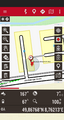
Coordinates reached in OruxMaps
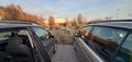
Looking east from the hashpoint (our car is on the left)
Looking west into sunset and construction site (had to crop the right half of the image with my parents)
Looking north from the hashpoint
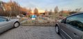
Looking east from the hashpoint (our car is on the right)
Stupidly grinning because I’m joyful about visiting my first geohash

Fun fact: Usually, I never take selfies! But geohashing gives me enough reason to do so.
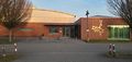
Zahlwaldhalle, east of the hashpoint
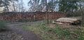
A bunch of timber lying around
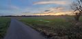
A beautiful sunset
Sunset view from our car
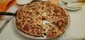
Enjoying a Pizza Margherita at Ristorante Tiramisu


Achievements
Green guy! (talk) earned the Land geohash achievement
|
Green guy! (talk) earned the Drag-along achievement
|
Green guy! (talk) earned the Two to the N achievement
|