Difference between revisions of "2024-07-16 48 7"
m (Location) |
(Coordinates reached) |
||
| Line 5: | Line 5: | ||
}} | }} | ||
== Location == | == Location == | ||
| − | + | On the left bank of the Hanfgraben brook in [[wikipedia:Mussig|Mussig]]. | |
== Participants == | == Participants == | ||
| Line 12: | Line 12: | ||
== Plans == | == Plans == | ||
[[User:Baarde|Baarde]] plans to cycle there in the evening. | [[User:Baarde|Baarde]] plans to cycle there in the evening. | ||
| + | |||
| + | == Expedition == | ||
| + | I cycled from Sélestat to the Hanfgraben brook, which acts as the limit between the Breitenheim hamlet in Mussig and the neighboring commune of Baldenheim. The brook is bordered by a thick wood, so I left my bicycle on a farm track about 60 metres from the hashpoint and bush-bashed the remaining distance. | ||
| + | |||
| + | The coordinates were located just about 1 metre from the water. I had come prepared and was wearing an old pair of hiking shoes instead of my nicer cycling shoes. Still, I was glad to keep my feet dry. | ||
| + | |||
| + | After recording proof, I dashed back home, completing the expedition in less than 41 minutes. | ||
| + | |||
| + | == Photos == | ||
| + | <gallery> | ||
| + | File:2024-07-16 48 7 01.jpg | My bicycle near the geohash | ||
| + | File:2024-07-16 48 7 02.png | Coordinates reached | ||
| + | File:2024-07-16 48 7 03.jpg | Surroundings (East) | ||
| + | File:2024-07-16 48 7 04.jpg | Surroundings (West) | ||
| + | File:2024-07-16 48 7 05.jpg | Stupid grin | ||
| + | </gallery> | ||
| + | |||
| + | == Tracklog == | ||
| + | {{tracklog | 2024-07-16 48 7 06.gpx}} | ||
| + | * Start: 19:05:39 UTC+2 | ||
| + | * End: 19:46:10 UTC+2 | ||
| + | * Duration: 40'31" | ||
| + | |||
| + | == Achievements == | ||
| + | {{#vardefine:ribbonwidth|100%}} | ||
| + | {{land geohash | ||
| + | | latitude = 48 | ||
| + | | longitude = 7 | ||
| + | | date = 2024-07-16 | ||
| + | | name = [[User:Baarde|Baarde]] | ||
| + | }} | ||
| + | {{bicycle geohash | ||
| + | | latitude = 48 | ||
| + | | longitude = 7 | ||
| + | | date = 2024-07-16 | ||
| + | | name = [[User:Baarde|Baarde]] | ||
| + | | distance = 14 km | ||
| + | | bothways = true | ||
| + | }} | ||
| + | {{Speedrun achievement | ||
| + | | latitude = 48 | ||
| + | | longitude = 7 | ||
| + | | date = 2024-07-16 | ||
| + | | name = [[User:Baarde|Baarde]] | ||
| + | | minutes = 41 | ||
| + | }} | ||
__NOTOC__ | __NOTOC__ | ||
| − | [[Category: | + | [[Category:Expeditions]] |
| + | [[Category:Expeditions with photos]] | ||
| + | [[Category:Coordinates reached]] | ||
{{location|FR|67}} | {{location|FR|67}} | ||
Latest revision as of 21:17, 16 July 2024
| Tue 16 Jul 2024 in 48,7: 48.2485930, 7.5229368 geohashing.info google osm bing/os kml crox |
Location
On the left bank of the Hanfgraben brook in Mussig.
Participants
Plans
Baarde plans to cycle there in the evening.
Expedition
I cycled from Sélestat to the Hanfgraben brook, which acts as the limit between the Breitenheim hamlet in Mussig and the neighboring commune of Baldenheim. The brook is bordered by a thick wood, so I left my bicycle on a farm track about 60 metres from the hashpoint and bush-bashed the remaining distance.
The coordinates were located just about 1 metre from the water. I had come prepared and was wearing an old pair of hiking shoes instead of my nicer cycling shoes. Still, I was glad to keep my feet dry.
After recording proof, I dashed back home, completing the expedition in less than 41 minutes.
Photos
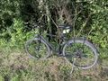
My bicycle near the geohash
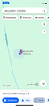
Coordinates reached
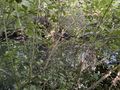
Surroundings (East)
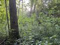
Surroundings (West)
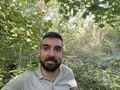
Stupid grin


Tracklog
- Start: 19:05:39 UTC+2
- End: 19:46:10 UTC+2
- Duration: 40'31"
Achievements
Baarde earned the Land geohash achievement
|
Baarde earned the Bicycle geohash achievement
|
Baarde earned the Speedrun achievement
|