Difference between revisions of "2024-04-13 49 8"
Green guy! (talk | contribs) (Finally add tracklog; remove pictures heading) |
Green guy! (talk | contribs) (Add captions and finalize layout of images; some other improvements) |
||
| Line 1: | Line 1: | ||
| − | |||
| − | |||
| − | |||
| − | |||
{{meetup graticule | {{meetup graticule | ||
| lat={{#explode:{{SUBPAGENAME}}| |1}} | | lat={{#explode:{{SUBPAGENAME}}| |1}} | ||
| Line 32: | Line 28: | ||
=== Arrival at the ''Waldgasthaus'' === | === Arrival at the ''Waldgasthaus'' === | ||
| − | [[File:OMIMG_20240413_171901.jpg|thumb| | + | [[File:OMIMG_20240413_171901.jpg|thumb|x150px|alt=view of hilly, green landscape in background with memorial stone in foreground|Loo­king east from the ''Wald­gast­haus'']] |
Upon reaching Reichenbach, we took the uphill one-lane access road to reach our car destination, ''Waldgasthaus am Borstein'' (an owner-operated guesthouse with a small restaurant). Contrary to what’s mapped in OpenStreetMap, the parking area didn’t require a fee; however, as we planned to visit the hashpoint, we had to check with the private owners of the facility, assuring them we would only be away for a short time to then eat from their kitchen (as the parking area is designated as guests only). | Upon reaching Reichenbach, we took the uphill one-lane access road to reach our car destination, ''Waldgasthaus am Borstein'' (an owner-operated guesthouse with a small restaurant). Contrary to what’s mapped in OpenStreetMap, the parking area didn’t require a fee; however, as we planned to visit the hashpoint, we had to check with the private owners of the facility, assuring them we would only be away for a short time to then eat from their kitchen (as the parking area is designated as guests only). | ||
| − | |||
=== Reaching the coordinates === | === Reaching the coordinates === | ||
| − | + | The hashpoint itself was to the left of the ''Vogellehrpfad''. In spite of the short distance from the track, the coordinates were comparatively difficult (and slightly dangerous) to reach as the terrain goes steeply uphill while there are also a lot of big rocks and boulders accompanied by somewhat slippy leaves. Thankfully, I didn’t injure myself in any way (and neither did my mom, who came with me), but standing on the exact coordinates and getting that screenshot of proof was tricky … | |
| − | <gallery | + | <gallery class="center" widths="100px" heights="200px"> |
| − | File:OMIMG_20240413_173140.jpg | + | File:OMIMG_20240413_173140.jpg | alt="looking up a slope with big rocks inside forest, sign in front of it" |Hashpoint lay up this slope |
| − | File:OMIMG_20240413_173253.jpg | + | File:Screenshot_20240413-173245_OruxMaps.png | alt="OruxMaps screenshot of almost reaching the coordinates" |Coordinates almost reached; after taking the screenshot, I went a bit more south, closer to the coordinates. |
| − | File:OMIMG_20240413_173312.jpg | + | File:OMIMG_20240413_173253.jpg | alt="rocky slope in the forest" |Coordinates a few meters ahead |
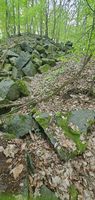
| − | File:OMIMG_20240413_173348.jpg | + | File:OMIMG_20240413_173312.jpg | alt="" |
| − | File:OMIMG_20240413_173359.jpg | + | File:OMIMG_20240413_173348.jpg | alt="" |
| + | File:OMIMG_20240413_173359.jpg | alt="looking down on my legs and leaf-covered ground" |Sitting on the coordinates after losing balance, but thankfully without injury | ||
</gallery> | </gallery> | ||
| − | + | After getting back on the way, me and mom walked a few hundred meters farther to visit an amphibians’ pond before turning around and, together, walking back to the guesthouse. | |
| − | + | <gallery class="center" widths="390px" heights="200px"> | |
| − | <gallery | + | File:OMIMG_20240413_174101.jpg | alt="swampy pond surrounded by bushes, path on the right side" |The amphibians’ pond |
| − | File:OMIMG_20240413_174101.jpg | + | File:OMIMG_20240413_174238.jpg | alt="low sun shining between forest trees" |Sun shining through the trees: majestic! |
| − | File:OMIMG_20240413_174238.jpg | ||
</gallery> | </gallery> | ||
| − | |||
=== Delicious dinner === | === Delicious dinner === | ||
| − | <gallery | + | When we got back, we were hungry and ready to eat some home-made food. At first, we comtemplated to have dinner indoors, but eating outdoors was a better choice as there was a beautiful meadow with a few tables and a delightful view downhill in front of the guesthouse. I decided on a delicious kids’ Viennese pork schnitzel (because adults’ servings are nearly always oversized for me) with french fries and plenty of ketchup. |
| − | File:OMIMG_20240413_180654.jpg | + | <gallery class="center" widths="390px" heights="200px"> |
| − | File:OMIMG_20240413_181846.jpg | + | File:OMIMG_20240413_180654.jpg | alt="empty table on meadow with trees in background" |Waiting for our meals while enjoying the quiet meadow |
| + | File:OMIMG_20240413_181846.jpg | alt="table with plates of food" |A mouth-watering schnitzel with corrugated fries | ||
</gallery> | </gallery> | ||
| − | |||
=== Driving back home === | === Driving back home === | ||
After eating our fill, we departed from ''Waldgasthaus am Borstein'' to drive back home, this time via the ''<span style="padding-right: 0.2em">A</span>5'' motorway. | After eating our fill, we departed from ''Waldgasthaus am Borstein'' to drive back home, this time via the ''<span style="padding-right: 0.2em">A</span>5'' motorway. | ||
| − | == Tracklog: Walking to the hashpoint | + | == Tracklog: Walking to the hashpoint and visiting the amphibians’ pond == |
* GPS accuracy: medium to good | * GPS accuracy: medium to good | ||
* Markers show all locations where I took photos (including non-public ones). | * Markers show all locations where I took photos (including non-public ones). | ||
Revision as of 10:17, 17 July 2024
| Sat 13 Apr 2024 in 49,8: 49.7172295, 8.6765203 geohashing.info google osm bing/os kml crox |
Location
In a forest, about 20 meters away from the closest track called Vogellehrpfad (“bird studies path”), in Bergstraße (“mountain street”) county, Hesse, Germany. The closest settlement is Reichenbach in east direction, and the famous Felsenmeer (blockfield) of Lautertal-Reichenbach lies in northeast direction. (This geohash already reminds me of an awesome trip to the Felsenmeer I had with my dad on May 29, 2023.)
This day’s weather: warm and sunny with thin cirrus clouds
Participants
- Green guy! (talk)
- Green guy!’s mother (no consent to publish photos of her)
- Green guy!’s father (no consent to publish photos of him)
Plans
- Drive to Waldgasthaus Am Borstein near Reichenbach
- Go on a quick walk to visit the hashpoint
- Maybe go on a walk to visit the nearby Felsenmeer or some other interesting attraction
- Have late-afternoon lunch at Waldgasthaus Am Borstein if the restaurant is open
- Alternatively, visit a restaurant or café in Bensheim
- Drive back home
Expedition
Route to Reichenbach
My parents and I drove towards Reichenbach, leaving Darmstadt in direction of Nieder-Ramstadt. When we approached the Modau valley, we had to take a detour from the initially-planned route due to a major road being blocked (except for residents), but that detour (going through Fischbachtal, where one of my previous expeditions took place) was most likely a good decision as it was easier to drive.
Arrival at the Waldgasthaus

Upon reaching Reichenbach, we took the uphill one-lane access road to reach our car destination, Waldgasthaus am Borstein (an owner-operated guesthouse with a small restaurant). Contrary to what’s mapped in OpenStreetMap, the parking area didn’t require a fee; however, as we planned to visit the hashpoint, we had to check with the private owners of the facility, assuring them we would only be away for a short time to then eat from their kitchen (as the parking area is designated as guests only).
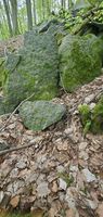
Reaching the coordinates
The hashpoint itself was to the left of the Vogellehrpfad. In spite of the short distance from the track, the coordinates were comparatively difficult (and slightly dangerous) to reach as the terrain goes steeply uphill while there are also a lot of big rocks and boulders accompanied by somewhat slippy leaves. Thankfully, I didn’t injure myself in any way (and neither did my mom, who came with me), but standing on the exact coordinates and getting that screenshot of proof was tricky …
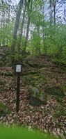
Hashpoint lay up this slope
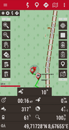
Coordinates almost reached; after taking the screenshot, I went a bit more south, closer to the coordinates.
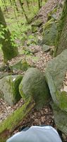
Coordinates a few meters ahead
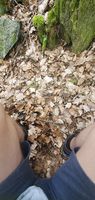
Sitting on the coordinates after losing balance, but thankfully without injury


After getting back on the way, me and mom walked a few hundred meters farther to visit an amphibians’ pond before turning around and, together, walking back to the guesthouse.
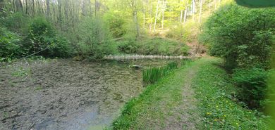
The amphibians’ pond
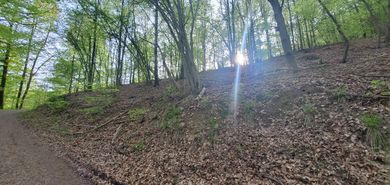
Sun shining through the trees: majestic!


Delicious dinner
When we got back, we were hungry and ready to eat some home-made food. At first, we comtemplated to have dinner indoors, but eating outdoors was a better choice as there was a beautiful meadow with a few tables and a delightful view downhill in front of the guesthouse. I decided on a delicious kids’ Viennese pork schnitzel (because adults’ servings are nearly always oversized for me) with french fries and plenty of ketchup.
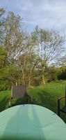
Waiting for our meals while enjoying the quiet meadow
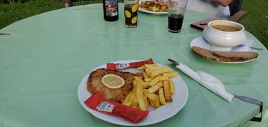
A mouth-watering schnitzel with corrugated fries


Driving back home
After eating our fill, we departed from Waldgasthaus am Borstein to drive back home, this time via the A5 motorway.
Tracklog: Walking to the hashpoint and visiting the amphibians’ pond
- GPS accuracy: medium to good
- Markers show all locations where I took photos (including non-public ones).
Achievements
First-time
I earned these for the first time from this geohash.
Recurring
I already earned these from an earlier geohash, but fulfilled the conditions again on this one.
Green guy! (talk) earned the Land geohash achievement
|
And no, drag-along doesn’t count as recurring because my parents are now sort-of familiar with the concept of geohashing (apart from not comprehending the Algorithm’s details).