Difference between revisions of "2024-06-17 48 11"
From Geohashing
| Line 28: | Line 28: | ||
{{Two to the N achievement | count = 1 | latitude = 48 | longitude = 11 | date = 2024-06-17 | reached = true | name = [[User:Iqui|Iqui]]}} | {{Two to the N achievement | count = 1 | latitude = 48 | longitude = 11 | date = 2024-06-17 | reached = true | name = [[User:Iqui|Iqui]]}} | ||
{{Two to the N achievement | count = 1 | latitude = 48 | longitude = 11 | date = 2024-06-17 | name = [[User:Iqui|Iqui]]}} | {{Two to the N achievement | count = 1 | latitude = 48 | longitude = 11 | date = 2024-06-17 | name = [[User:Iqui|Iqui]]}} | ||
| + | {{Two to the N achievement | count = 0 | latitude = 48 | longitude = 11 | date = 2024-06-17 | name = [[User:Feyi|Feyi]]}} | ||
| + | {{Two to the N achievement | count = 0 | latitude = 48 | longitude = 11 | date = 2024-06-17 | reached = true | name = [[User:Feyi|Feyi]]}} | ||
__NOTOC__ | __NOTOC__ | ||
Revision as of 12:17, 2 August 2024
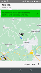
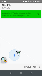
| Mon 17 Jun 2024 in 48,11: 48.2738083, 11.4162476 geohashing.info google osm bing/os kml crox |
Location
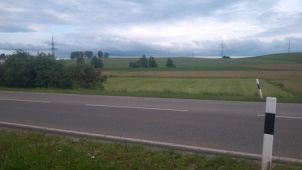
In Webling (Dachau) in the middle of a meadow
Participants
Expedition
- Iqui: The hash was pretty well accessible, just next to a bigger street in the middle of a grassy field. The distance from my starting location was also quite pleasant and it made for a nice little biking trip.
Photos

distance
proof 1
proof 2
location


Achievements
Iqui and Feyi earned the Land geohash achievement
|
Iqui and Feyi earned the Bicycle geohash achievement
|
Iqui earned the Two to the N achievement
|
Iqui earned the Two to the N achievement
|
Feyi earned the Two to the N achievement
|
Feyi earned the Two to the N achievement
|