Difference between revisions of "2024-08-05 58 5"
From Geohashing
(→Expedition) |
(→Photos) |
||
| Line 39: | Line 39: | ||
Image:2024-08-05_58_5_Pica42_1722846157868.jpg|Myrland [https://openstreetmap.org/?mlat=58.92003660&mlon=5.91971690&zoom=16 @58.9200,5.9197] | Image:2024-08-05_58_5_Pica42_1722846157868.jpg|Myrland [https://openstreetmap.org/?mlat=58.92003660&mlon=5.91971690&zoom=16 @58.9200,5.9197] | ||
| + | Image:20240805 58 5 NE.jpg|thumb|View to the northeast | ||
| + | |||
| + | |||
| + | |||
</gallery> | </gallery> | ||
Revision as of 14:45, 9 August 2024
| Mon 5 Aug 2024 in 58,5: 58.9200070, 5.9197153 geohashing.info google osm bing/os kml crox |

Location
In a mountain pasture for sheeps and cows at Myrland, Sandnes, Norway.
Participants
Plans
Expedition
On this day I was unsure if the weather would be good enough to find a hash point, it was. In addition to the geohash, I also found three geocaches in the area.
Tracklog
Photos

Myrland @58.9200,5.9197
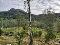
View to the northeast


Achievements
Pica42 earned the Land geohash achievement
|