Difference between revisions of "2024-08-03 47 -122"
From Geohashing
| Line 10: | Line 10: | ||
== Expedition == | == Expedition == | ||
| − | + | Reasonable bikeride, but I didn't trust google maps. It tried to save me from a hill, which I ended up having to take. Got some lemonade on the way back from a lemonade stand and then had to brave the hill on the way down... | |
| − | + | == Photos == | |
| − | |||
| − | |||
| − | == Photos == | ||
| − | |||
| − | |||
| − | |||
<gallery perrow="5"> | <gallery perrow="5"> | ||
| + | File:2024-08-03 47 -122 Trailhead.jpeg | Trailhead | ||
| + | File:2024-08-03_47_-122_Pipeline.jpeg | So that's why it's called a 'pipeline trail'. | ||
| + | File:2024-08-03 47 -122 The Hill.jpeg | I'll never doubt you again, google maps. | ||
| + | File:2024-08-03 47 -122 Destination reached.png | Victory. Only a few minutes late. | ||
</gallery> | </gallery> | ||
| − | |||
| − | |||
| − | |||
| − | |||
__NOTOC__ | __NOTOC__ | ||
| − | |||
| − | |||
| − | |||
| − | |||
| − | |||
| − | |||
| − | |||
| − | |||
[[Category:Expeditions]] | [[Category:Expeditions]] | ||
| − | |||
[[Category:Expeditions with photos]] | [[Category:Expeditions with photos]] | ||
| − | |||
| − | |||
| − | |||
| − | |||
[[Category:Coordinates reached]] | [[Category:Coordinates reached]] | ||
| − | |||
| − | |||
| − | |||
| − | |||
| − | |||
| − | |||
| − | |||
| − | |||
| − | |||
| − | |||
| − | |||
| − | |||
| − | |||
| − | |||
| − | |||
| − | |||
| − | |||
| − | |||
| − | |||
Revision as of 22:22, 10 August 2024
| Sat 3 Aug 2024 in 47,-122: 47.7371133, -122.0500816 geohashing.info google osm bing/os kml crox |
Location
Someone's backyard in Cottage Lake, Washington. The road is close enough for my tastes (~200 ft)
Participants
Plans
Planning to bike up at around 3 PM, should be there at 4, weather permitting. Will bike back if nobody shows up, otherwise happy to hang out for a bit.
Expedition
Reasonable bikeride, but I didn't trust google maps. It tried to save me from a hill, which I ended up having to take. Got some lemonade on the way back from a lemonade stand and then had to brave the hill on the way down...
Photos
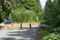
Trailhead
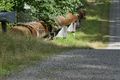
So that's why it's called a 'pipeline trail'.
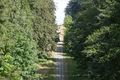
I'll never doubt you again, google maps.
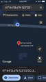
Victory. Only a few minutes late.


