2009-04-18 49 -123
| Sat 18 Apr 2009 in 49,-123: 49.0845888, -123.8377370 geohashing.info google osm bing/os kml crox |
Contents
Location
At Friday dawn, we discover that this week's Saturday location is in an agricultural field less than ten kilometres from the Duke Point ferry terminal in Nanaimo. It's not in the water; it's not on a mountain; it's not at the military base; it's just in between Quennel Road and Yellow Point Road.
Planning
The reason the non-water, non-mountain aspects of this hashpoint are so important is that Robyn declared in advance that she would attend this geohash, even if it took two days to get there. Thepiguy also committed himself to the adventure. Robyn announced:
On Thursday I will prepare everything I could conceivably need for a Vancouver geohash. That means bike, kayak, wetsuit, hiking boots, ferry schedules, T-Rex, bear repellent, ambassador letter, compass, GPS and camera batteries and spares charged, games, chalk, tent, sleeping bag, stove, food, and somewhere I can rent snowshoes borrowed from thepiguy.
Then at 6:30 a.m. on Friday, I will check the coordinates. If they are in a remote area I will spend at least an hour planning and researching routes, before I set off in search of the geohash.
Vancouver must not defy me!
See the talk page for more details on how you plan an expedition without knowing where you are going.
After knowing the coordinates
Robyn, and the people who hoped to geohash with her again in the future (especialy the one who had agreed to go with her), were very relieved to have the coordinates be merely a two hour ferry ride away, with no spring mountaineering or 20 km kayak trips.
The first plan was all ready, when thepiguy spotted a doable hash in another graticule on a road that forbade bikes, so a new plan was announced and executed with only a few completely unplanned aspects, then Robyn was released to reintersect her original plan: ferry to Duke Point, bike to the geohash field, get permission and celebrate!
Participants
- Robyn who started this, and T-Rex of course
- thepiguy who was very relieved that he wouldn't have to hike half way to Whistler.
Non geohashers attending
- Betty, the organic chicken farmer
- George, husband of the above
- Whiskey, the dog that is older than thepiguy
- 48 unnamed organic chickens
Expedition
Waiting for the ferry
Robyn, T-Rex and Успех (Robyn's bike) were dropped off at the Ladner bus exchange, thence a quick 13 km trip to the Tsawwassen ferry terminal, putting Robyn at the terminal almost two hours before the next sailing to Duke Point. Robyn entertained herself by talking to the other people waiting for the ferry, and documenting them for your education and entertainment.
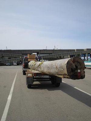
First we have the man towing an enormous log on a trailer. Note the red reflector simply nailed to the trailing end of the log. The man was taking the log home to carve it into a totem pole, the traditional icon of family power and history in the northwest coastal region. He estimated it would take about sixty hours to finish, using modern powered tools. He would sell it when it was complete. Before Robyn had a chance to ask him which legend or family totems it might depict, he took a cellphone call and it lasted a while so Robyn walked off to investigate the next interesting truck.
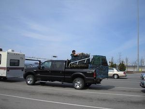
This man was lying comfortably inside what looked like a giant mesh-walled bucket. "Are those giant crab traps?" Robyn asked, although they didn't really look like crab traps.
"They're black cod traps," the fisherman explained. The trap is baited with squid and a few hake then lowered to the sea bed with a line and buoy attached. The cod can get into the trap through holes that are big enough for mature cod to enter, but not big enough for the largest spawning fish, so as to allow them to lay their eggs and increase their population. The inside of the hole is lined with a net sleeve, such that for a fish to turn around and get out of the trap would be like you trying to put your arm in a shirtsleeve while it's inside out. And fish don't have thumbs. A small hole in the side of the trap has no sleeve, so that immature cod and smaller non-target species can swim out easily. The trap is left down for about twenty-four hours (much longer and decreased mobility makes fish susceptible to sea lice). Typically ten or twelve fish are in the trap but the fisherman said he'd seen as many as a hundred.
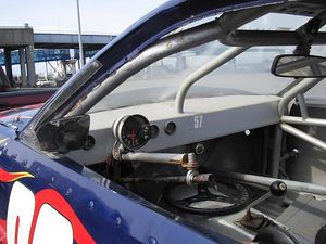
Another truck was transporting live crabs, and the one in the last lane had a race car on it. Robyn looked at the instrument panel for the race car and laughed because it consisted of one giant tachometer and a couple of tiny oil pressure and oil temperature gauges. "I guess you don't need to know how fast you're going as long as you're going faster than everyone else?" Robyn asked the driver, and he agreed. Two more race car drivers arrived towing their cars, all going to a race in Langdale. The cars weren't street legal, with everything non-essential to racing removed, but one of them amusingly had stickers on the front fairing simulating headlights and turn indicators like on a normal car. The race car drivers were engrossed in a discussion of engine modifications.
During this time thepiguy arrived, having dropped Elbie off and changed into biking gear, after the previous geohash. He mentioned that his mother was concerned about his meeting an axe murderers at a geohasher. But he concluded, "If someone is going to go to this much trouble to kill me, I say they've earned it."
From the ferry to the geohash
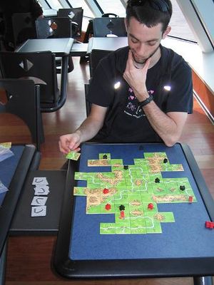
During the two hour ferry ride, thepiguy taught Robyn how to play Carcassonne. Pi had left the scoreboard in the pannier and Robyn was more interested in making pretty roads and rivers than actually scoring points, so they played a cooperative variation where you don't keep score, and just take turns adding tiles, trying to build the most impressive cities and roads possible, and randomly placing coloured meeple wherever they look nice. We also ate ferry food and watched the passage of scenery so amazing that people from other graticules spend a lot of money to cruise through.
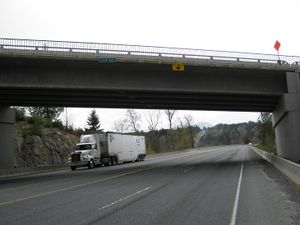
After we docked at Duke Point, we rode off the ferry and up a cruelly designed ultra-steep exit ramp designed especially for cyclists, to give us a head start on the cars, getting onto highway 19. The geohash was 10 km ahead. Google Maps had shown Cedar Road as crossing highway 19 and heading towards the geohash, so we watched for it. We have to admit that it did cross the highway, but not in a way that was useful to someone who couldn't jump at least eight metres vertically. We turned around and took a dirt path from the highway to another road that crossed the highway on another such overpass.
This took us through the community of Cedar, and onto Cedar road in a more convenient fashion. The GPS needle swung abeam our track and pointed three kilometres into swamp. Ugh. What kind of land would we have to contend with? We stayed on the road and continued to draw closer. Within a couple kilometres of the geohash we were passing undeveloped, unfenced land (yay!), horse runs (unlikely to get permission), a cellphone tower (proabbly no access, but might have good paths around the restricted area. Then four hundred metres from the geohash, and almost abeam was a farm gate. It didn't say no trespassing and it was open, so we turned down it. It ended after a hundred metres at a fancy closed gate, in front of a beautiful home. The geohash, it was now evident, was in a field just to the left of the driveway we had come down. Behind the gate, two big barking dogs and one little barking dog announced our arrival, the smallest one so enthusiastic that it kept leaping onto the back of one of the other dogs in order to bark at us more threateningly. The dogs brought the attention of an owner.
Robyn greeted her, praised the house and the enthusiastic dogs and asked if she owned the adjacent field. She didn't but knew who did, and directed us. We thanked her and rode past the field containing the geohash to the next driveway, where a sign announced eggs for sale. The family name on the egg business wasn't the same as the name we'd been given for the owner, but the directions matched, and a sign advertising farm produce for sale is surely an invitation to come in and buy said produce. We rode up the driveway.
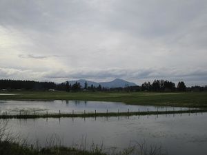
Part way up there was a right turn to a flat area where there was a camping trailer, a couple of old rusted tractors, an anvil and other detritus that suggested this was the farm junkyard/long term storage area. Robyn turned into it because a) the hill was very steep and b) it seemed to afford a good view of the geohash. We determined from there that the geohash was definitely in the field we saw, and fortunately as not in the flooded portion thereof.
As close as we needed to be
We continued up the steep road to the farmhouse, where we met Betty. She said her brother-in-law owned the adjacent field, and that it was a hay field. That sounded really promising, but she said we'd have to phone him to ask for access to the field. We asked if she had the telephone number, which she did, but then told us we were not coming in her house, and that he probably wouldn't let us in the field, and furthermore because this was a poultry farm and subject to federal biohazard regulations, she would have to record our names and addresses for the government. Robyn, as conciliatory as she could be, thanked her for the information about the field, and assured her that we had our own telephones, and were quite willing to give her that information. Pi backed her up, making motions and noises to get out pen and paper and record such addresses. A little confused, and not wanting to say, "But the sign says eggs for sale! How were we supposed to know?" Robyn asked carefully, "Does that mean that you have to get the addresses of everyone who buys eggs?" She did, and the question allowed Betty to transfer her irritation from the geohashers to the government and its avian flu regulations. The house was off limits not because we were evil geohashers, but because whoever else remained therein was suffering from flu of the human variety.
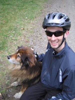
The ice somehow broken, the encounter turned into a forty-five minute tour of an organic checken farm. We examined numerous examples of antique farm equipment, learned the details of every mountain peak, field, and building within sight of the farm, and met Whiskey, a part Akita dog born sometime in the mid-1980s, making him older than thepiguy, but still way better at fetching sticks. Chickens lay an egg a day for the first year or so and then an egg every second day thereafter. Meat chickens have so much meat on their breasts that they can't get onto perches. They came with us to survey the geohash from the best vantage point on their farm. The field just this side of the one containing the geohash was flooded, but would be planted with corn when the lake waters subsided. The fence was down there because a black bear had pushed it over last year after getting drunk on fermented windfall apples, then rolled around in the corn. Robyn laughed, "like drunk teenagers doing doughnuts" and Betty agreed with the analogy but maintained that it wasn't funny, that corn was a lot of trouble to grow. After that, the bear headed across the other field and got stuck in the pea. It was stuck there for a day and the owner of the field was wondering if he should get his tractor and pull it out. (I vote no to hooking your tractor to any sort of bear, but especially the pissed off, hungover, hungry, stuck kind). Fortunately the bear got out on its own and headed for the sea where it ate some spawning salmon.
Robyn asked how many chickens there were, estimating about fifty and was so proud of her chicken estimating skills when she was told there were forty-eight, that she gave herself a gratuitous ribbon for it.
Betty told us we should stay longer next time, that we could bring a tent and camp on her land, and she thanked us for having the courtesy to attempt to obtain the farmer's permission and not trespassing. We explained that was the way our sport is conducted, that it was just as fun to not reach a point and meet interesting people as it was to reach the point. And we meant it. We biked back the way we came, drawing abeam our target field, and we looked in towards the point. "Are we going to call?" we asked. We had the number, and nothing to lose. "Nah," we said. We'd really had as much adventure as we needed. We photographed the sign (yes, it said POSTED) and rode back to the ferry.
On the way back we played Carcassonne again, this time with the scorecard, and thepiguy soundly trounced Robyn, getting all six churches, but Robyn didn't mind, because we made some very pretty roads and churches. Pi dropped Robyn and her possessions off at home, so that was the end of the adventure.
Pi will have pictures of the chickens, soon.
