2011-09-14 50 11
| Wed 14 Sep 2011 in 50,11: 50.8697216, 11.4432700 geohashing.info google osm bing/os kml crox |
Location
On a meadow near Tromlitz. Should be easy to get there.
Participants
- Juja and the Ninja
Expedition
This was another not-so-well-planned expedition. Ok, the Edge battery was full and I had a camera with me (and my bike, of course), but neither biking clothes nor even warm clothes nor any food or drink. The latter was especially bad: I went swimming before, and since the trainer did not know that I planned on cycling to a hash afterwards he made us do the most exhausting exercises. Luckily, I found an old cereal bar in my backpack and just hoped this would be sufficient to make up for the lost energy and take me the 20 kms to the Geohash point (and the same way back).
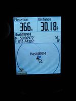
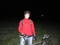
Surprisingly I even had a Ninja at my side (in the original sense... like this), so we cycled there while it got dark, took proof photos in complete darkness and cycled on home. Bonus info: those clear nights can be veeery cold.
Photos
|
Lessons learned
- The sun goes down earlier now than in June. Who'd have thought that? ;)
- There's an "R" in "September", so I should wear an undershirt, find my long socks and always have long biking gloves with me. Oh, and no more open water swimming, too...

