2013-05-10 62 27
| Fri 10 May 2013 in 62,27: 62.8732713, 27.5275140 geohashing.info google osm bing/os kml crox |
Location
In Puroniitty, Haminalahti, Kuopio. The point is about 50 meters from the nearest house, which is possibly a summer cottage. (This was false preassumption, as we later found out.)
Participants
Plans
Tilley: A very fortunate hash for today! My dad, Pastori, and mom were coming to visit the very day, and the hash fell only 6,8 km from our home as the crow flies, and about 11 km by road. A chance to make it a mega-meeting, at least in terms of this graticule. A group of five has been on the hashpoint only once. I'm going to get the whole bunch to travel by bikes, too, although it is only the second biking trip for this summer for Pastori and Wife. Thus needed to chance some tires and make other adjustments to mine and my wife's reserve bikes.
Expedition
Pastori and The Wife effectively started their hashing trip by first driving 160 km to Tilley's place. After some socialising and eating it was time for the youngest member of the hashing expedition team to go for her afternoon nap. So we packed her along with our other stuff, made final adjustments to the bicycles and set on our way.
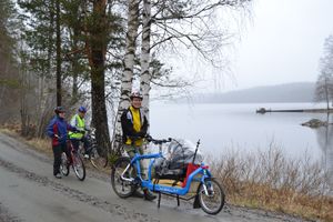
The weather was very refreshingly moist. That meant that if we stood still we couldn't notice any rain, but when riding our glasses were quickly filled with little rain droplets, obscuring view. Nevertheless our caravan advanced steadily and Pastori and The Wife especially were enjoying the smooth surfaces of tarmac cycling roads, a major improvement for their usual cycling grounds.
After about 9 km of riding we turned to a gravel road. Pastori and The Wife felt again like home, or actually, remembered how sluggish riding on a wet clay-surfaced gravel road felt. Our party didn't let this affect our mood, because the scenery was very nice. After some open fields and country houses, the road turned to follow right alongside the shore of the lake Kallavesi. The views from the road were idyllic despite the almost foggy weather. The road was very narrow but there weren't much traffic, the whole time about 5 cars passed us.
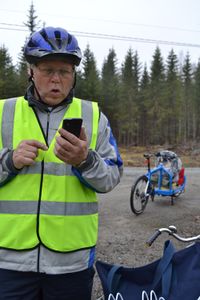
We approached the hashpoint, and were surprised that there was a brand new house very near the hashpoint. The house had apparently been built the previous year or so, the yard was still not finished. I had previously looked from map that the point would fell a little out of the driveway, but now my GPS was pointing straight along it. Pastori's smartphone was of no help, because it decided not to update it's position anymore after being about 20 meters from the hash, despite of walking at a circle of at least 10 meters. Pastori was devastated by this, but we decided to rely on the eTrex. The exact point seemed to be right beside a pile of firewood and an outdoor compost loo. There was no line of sight from the point to the house, so we just stepped to it and posed for a picture. Our youngest team member was so soundly asleep that we didn't detach her crib from the bike. Apparently there also was nobody home, after all it was a regular weekday, and our party just happened to consist of couple of pensioners, a full-time dad and a student with irregular schedules, so we had nothing more important to do in daytime than to visit hashpoints.
After taking the necessary pictures for proof there still was nobody coming to question what we were doing there, and our courage was heightened. So we also ate some of our provisions and posted the "Internet was here" -sign to a nearby tree. Then we turned to head back. Return trip went uneventfully, and we safely arrived home after riding 21,7 km with an average speed of 13,9 km/h, which Pastori and The Wife will probably feel in their buttocks the day after.
Additional photos
Tilley hunting for hashpoint.
Achievements
Tilley+wife and Pastori+Wife earned the Bicycle geohash achievement
|


