2019-07-06 54 13
| Sat 6 Jul 2019 in 54,13: 54.0584436, 13.6036003 geohashing.info google osm bing/os kml crox |
Contents
Location
South of Neu Boltenhagen, MV, Germany, behind someone's backyard in a field.
Participants
Plans
Grab Winterbuche in the morning, don't know exactly when, and bike to the hash. If I am quick enough, I might be able to have lunch back at home.
Expedition
Today was not the most sunny day. It was raining a bit in the morning, and it might be going on and off until the afternoon, but it was a very thin rain. Typical north-german weather. I had a route in mind, and could do it clockwise or counter-clockwise. Since I had a 2 hours window with no rain forecast, I decided clockwise, this way and the way back I would be going through forest area and in case of rain I would be more protected. It kind of worked.
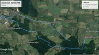
Another thing that had me worried was that my GPS did not have much battery. I noticed that yesterday but I overestimated it... ¿^^ That meant that the GPS died mid route, before reaching the hash. Luckily I had my phone with me and I used it as GPS. You may notice that the tracklog skips a part.
Concerning the expedition: Everything went more or less as planed. Cloudy day but the first part was done easily. I had a few caches to search along the route, but I had no luck in this aspect: all of them (3) were DNFs. Then the GPS stopped working. Well, I was almost there, I knew what path to take.
I saw that the hash fell behind a backyard of a house near a field. Being Saturday and not a sunny day there was not much going on there. I could approach the hash easily and taking pictures of the field in case anyone wondering what I was doing there. Then it is when it felt like it was going to start raining again. Luckily, as said, the way back was through forest and I did not feel much.
So, after the hash, I went through Hanshagen (becoming a typical passing point on my hash expeditions), and here was when it was raining more heavily. 20 minutes that I had to bike fast, passing by Friedrichshagen and a final sprint until I arrived at the NSG Eldena, again in the forest and protected from rain. But I was already slightly wet, not soaked, but uncomfortable enough. However, I was already only a few kilometres away from home.
The rest of the expedition was routine. With the particularity, that I took another path as usual, so that I could satisfy the tron achievement. However, I might not be able to claim this one. Not important. The expedition was a success :)
Tracklog
Photos
Achievements
SastRe.O earned the Land geohash achievement
|
SastRe.O with Winterbuche earned the Bicycle geohash achievement
|
SastRe.O earned the Drowned Rat Geohash Honourable Mention
|
Is it true that SastRe.O earned the Tron achievement?
|
Other Geohashing Expeditions and Plans on This Day
Expeditions and Plans
| 2019-07-06 | ||
|---|---|---|
| Rochester, New York | Mcbaneg, Susanne | wooded lot near Rush-Henrietta Senior High School, Henrietta, NY |
| München, Germany | Claralucia9 | in the middle of a rye field between Unterhaching and Taufkirchen, south ea... |
| Frankfurt am Main, Germany | GeorgDerReisende | The hash lay in the forest of Frankfurt am Main. |
| Leeuwarden, Netherlands | FelixTheCat | Nijland, municipality of Súdwest-Fryslân, Friesland province, Netherlands. |
| Stralsund, Germany | SastRe.O | South of Neu Boltenhagen, MV, Germany, behind someone's backyard in a field... |


