| Wed 28 Oct 2020 in 43,-79: 43.6510216, -79.3876253 geohashing.info google osm bing/os kml crox |
Location
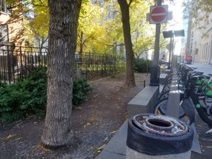
The Bike Share Toronto location at Queen and Simcoe.
Participants
Expedition
I was pleased to see this very accessible hashpoint and decided to use it as an excuse to get some shopping done downtown.
I took the subway from Warden and right away the journey was fraught! Someone threw a branch onto the tracks and the operator had to go out and retrieve it. Then, not too far from where we stopped for that, the train ran a red signal, which automatically causes an emergency stop. When this happens, the operator has to get out and manually restart the train. The poor guy deserved a break, I think!
At Dundas station I walked a block west to go to the Best Buy to purchase some consumer electronic goods. Afterwards, I headed south to Queen Street so that I could walk past City Hall. I think it's a really attractive building, and it was pleasant to walk through the heart of downtown, looking at the buildings and listening to the buzz of the city.
The hashpoint was a couple of blocks west, at a Bike Share Toronto location next to the Campbell House, which is an old judge's house that now functions as a museum. The GPS signal was really bad, presumably due to the nearby tall buildings. After snapping a few pictures, I took the Queen streetcar back east and walked home from about Queen and Woodbine, which is a nice walk that I do occasionally for non-geohashing reasons.
Photos
Achievements
Frogman earned the Public transport geohash achievement
|
This hashpoint is in Old Toronto, qualifying me for:
Frogman earned the Subdivision geohash achievement
|


