2024-04-21 50 8
| Sun 21 Apr 2024 in 50,8: 50.2448582, 8.7472927 geohashing.info google osm bing/os kml crox |
Location
In a field, about 50 meters west from Friedberger Straße (B3), in Wetterau county, Hesse, Germany. The closest settlement is Okarben in northeast direction; and the Berufsbildungswerk Südhessen (“vocational training unit of southern Hesse”) is located to the south.
This day’s weather: rainy and soft-haily at first, but then sunny with clouds, however still really cold and windy (typical April weather)
Participants
- Green guy! (talk)
- Green guy!’s mother (no consent to publish photos of her)
- Green guy!’s father (no consent to publish photos of him)
Plans
- Drive to Okarben after being done with this Sunday’s church service at CGD
- Have lunch at a restaurant in Okarben
- Go on a short walk (as the weather is quite cold) to visit the hashpoint
- Drive back home
Expedition
As planned, after Sunday church service, my parents and I drove to Okarben via motorway A661 and trunk/primary road B3. In Okarben, I enjoyed a tasty Pizza Margherita at Pizzeria Il Gelato Da Salvo.
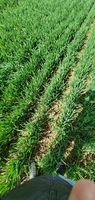
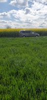
After lunch, we drove near the hashpoint and contemplated where to park our car … Since crossing Friedberger Straße (B3) (a primary road!) from east to west was way too dangerous, we instead drove onto a track road for a few minutes. This gave me time to reach the coordinates by foot. We had good luck with the hashpoint’s field being low-grown, as the tall-grown field on the other side was a beautiful, but impassable thicket of rapeseed plants. While I stepped towards the coordinates (requiring a jacket as there was a cold blowing of wind), my mom was exalted by the rapeseed (how the sun shone through it and how the wind caused it to reciprocate/resonate), recording a short video to post in her Instagram story. After being done, we drove back onto the primary road in reverse gear. Expedition successful!
Pictures
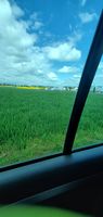
Looking at the hashpoint from our car
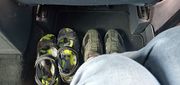
Changing from sandals to shoes
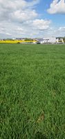
Walking to the hashpoint
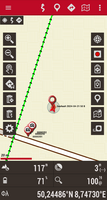
Coordinates reached

Funny grin, camera looking southwest
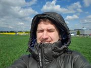
Funny grin, camera looking northeast
Standing on the coordinates
Walking back to our car
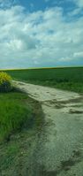
Looking back at the track road


Achievements
Recurring
I already earned these from an earlier geohash, but fulfilled the conditions again on this one.
Green guy! earned the OpenStreetMap achievement
|
Green guy! earned the Land geohash achievement
|
And no, drag-along doesn’t count as recurring because my parents are now sort-of familiar with the concept of geohashing (apart from not comprehending the Algorithm’s details).