2008-09-29 49 11
| Mon 29 Sep 2008 in Nuremberg, Germany: 49.0066368, 11.9874894 geohashing.info google osm bing/os kml crox |
dawidi
Today we performed an "inverse drag-along", for lack of a better achievement to call it by.
The hashpoint happened to be very close to my friend Tomcat's home (he's unregistered) in Eilsbrunn, and it's a long uphill ride for me to get there from Regensburg. He cycled to the hashpoint first, then rode downhill and met me at around two thirds of the way, after which we went to the coordinates again and arrived around sunset.
The exact point was in a currently unused (and dry!) field, so this time it was reachable and GPS reception was fine.
It was about to get dark, so we just took a few quick pictures and left.
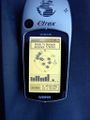
Within 60cm of the hash. The GPS fix just drifted away a bit while I was bending over it to take the picture... srsly!
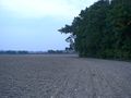
Looking north from the hash.
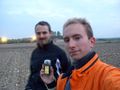
Looking south from the hash. Tomcat and dawidi.


