2010-10-16 53 9
For his first five geohashes, mtu had the wrong map datum set on his GPS device—namely the Potsdam datum instead of the globally accepted standard, WGS 84—causing him to not visit the actual, canonical hashpoints, but places about 200 m away in SSW-erly direction.
In all cases, the actual hashpoints would have been easily accessible, but were missed by 20–200 m solely due to mtu's ineptitude.
In commemoration of this epic fail,
mtu earned the False Start Consolation Prize
|
As a consequence, all achievements formerly claimed for this hash are null and void (except Drag-along achievements). Instead,
mtu earned the Blinded by Science Consolation Prize
|
Please note that the expedition narrative was written before this became known!
| Sat 16 Oct 2010 in 53,9: 53.6937638, 9.8175575 geohashing.info google osm bing/os kml crox |
Location
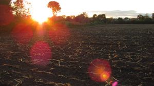
On a corn field (which by this time of years was all harvested and ploughed up, so no plants were harmed!) near Borstel, a one-horse-town near the town of Pinneberg.
Participants
Planning
| “ | Unknown, but it would appear that someone is planning something
|
” |
—Comment from before the expedition, but when the page already existed.
| ||
So we were indeed! :) We had meant to pick up a rental bike on the way so we could reach the has faster from the final train station of the S3 line, but it turned out they were too expensive. After some more research, it turned out there was a bus which stopped very close to the hash, so we decided to get on that.
Expedition
After getting off the bus, it was only a matter of walking half a kilometer. We were lucky the hash wasn't on the neighboring municipal water recycling facility's grounds, but on an openly accessible ploughed-up corn field. We did the GPS dance until we stood right on the hashpoint, and there was much rejoicing. We took some snaps, found two beers that were growing on the field and happily headed home.
We missed the bus back by about one minute (we gave it a friendly wave, though, as it sped away from us). On the way back, two women asked us for the way to this-and-that street. seamus_d routinely apologized and explained we were not locals, but I realized that what I had in my hand was a GPS. So we guided the two ladies on their way and inquired about their destination, as they were carrying a heavy bag between them. As it turned out, they were heading for a Polterabend, a German wedding tradition where on the eve of the wedding, friends and family come together, drink and noisily smash up old dinnerware for shits and giggles (and good luck to the happy couple, which usually have to clean the place up sometime during the party, just for the smashing to begin afresh).
We caught the train home right in time and are now eagerly waiting for our self-made pizza! Success!
Photos
Check activegeohasher.com for this goodie
Achievements
mtu and seamus_d earned the Land geohash achievement
|
mtu and seamus_d earned the Public transport geohash achievement
|


