2011-07-04 66 25
From Geohashing
Revision as of 14:57, 4 July 2011 by imported>Isopekka

| Mon 4 Jul 2011 in 66,25: 66.4696023, 25.6514400 geohashing.info google osm bing/os kml crox |
Contents
Location
About 5 km to the SE from my home, in Paavalniemi, on the wet shore of the river Kemijoki.
Plan
I will check if I can reach this maybe wet hashpoint.
Participants
Expedition
- By car total 10 km
- Walking total 1 km
- Expedition took 0.5 h
- Physical effort (1-5):2
Photos
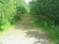
Along this road...
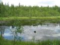
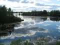
There it is, on the other side of this water.
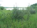
The Hashbush.
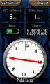
The Proof.
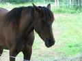
The Hash Horse on the way to the geocache.
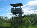
The Birdtower of Paavalniemi.
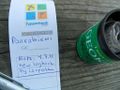
The Geocache GCVWW9.
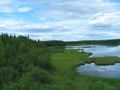
The view from the birdtower towards the hashpoint.
The view to the opposite direction.


Achievements
isopekka earned the Land geohash achievement
|
isopekka earned the Hash collision honorable mention
|
Geohashing Expeditions and Plans on This Day
Expeditions and Plans
| 2011-07-04 | ||
|---|---|---|
| Wanganui, New Zealand | Greenslime | About 25 m from roadside off SH49, close to Waiouru Military Camp |
| Crestview, Florida | Liberian, A non | A few tens of feet west of the very end of FIM Boulevard in Fort Walton Bea... |
| Newark, New Jersey | Jevanyn | A field on Township Line Rd. in Hillsborough, Somerset County, NJ. |
| Portland, Oregon | Michael5000 | A house at SE 14th and Malden, in Sellwood. |
| Mannheim, Germany | ilpadre | In Schriesheim, about 9 km north of Heidelberg. Next to a street and hopefu... |
| Norwich, United Kingdom | Sourcerer | On the south bank of the river Waveney east of Beccles, Suffolk, UK. |
| Rovaniemi, Finland | isopekka | About 5 km to the SE from my home, in Paavalniemi, on the wet shore of the ... |