2015-01-04 47 -122
| Sun 4 Jan 2015 in Seattle: 47.5701305, -122.2877733 geohashing.info google osm bing/os kml crox |
Location
An alley just north of Rainier Square Plaza in south Seattle, near the Charlestown Hill Climb.
Participants
Plans
Flexible; mid-day perhaps? Also need to find out if Charlestown refers to a street or neighborhood name, for tale-of-two-hashes purposes.
- I think it's pretty clearly the Charlestown *street* hillclimb - see the street name immediately south of the hashpoint, which runs right into the steps (and continues east of them after a brief interruption...) -- OtherJack (talk) 12:47, 2 January 2015 (EST)
Expedition
Raining in Seattle, but snowing over the rest of the country so I should count myself lucky. Drove to this south Seattle location and found the bottom of the Charlestown Hillclimb easily. Snapped a picture of that and of some rather bright buildings next door - hoorah for primary colors! Hashpoint was up an alley with even more of the modern dwellings under construction; was able to park on top of it. Before heading home, we swung around to the top of the hillclimb for one more photo. The metal "tree" has a periscope, but the mirror behind the eyepiece was hopelessly dirty. The top mirror may have been missing also - there was no change in light or color with rotation.
Photos
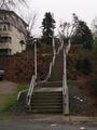
Hill climb @47.5698,-122.2873
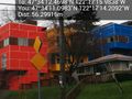
Lovely primary colors @47.5697,-122.2873


