2016-04-28 48 8

| Thu 28 Apr 2016 in 48,8: 48.5355529, 8.9962233 geohashing.info google osm bing/os kml crox |
Location
Forest next to Hagelloch, Tuebingen, Germany
Participants
Plans
A too-close-to-let-go hash. Unfortunately, plans are quite tight, but I think I can squeeze it in at around 17:30. Hopefully it's not raining!
Expedition
After I wasn't able to geohash in March, I finally had an easy opportunity to at least fulfill my current geohashing-goal (1 geohash/month) in April. I had to rearrange plans and started at 19:30.
It was nice weather, but a little muddy from the rainfalls from the last days. I was cycling very slowly, in fact I even stopped for a 20min telephone call in between.
The geohash was quite unspectacular in the forest. Nothing much to tell, stupidity distance was 500m, so I actually was walking quite a bit through steep forest. Little bit of hashdancing was required because of forest, too.
I was back at 21:00 before it got dark completly (which is good, because some idiot stole the backlight of my bicycle recently).
Photos

Proof
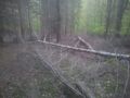
I decided to declare the non-broken tree in the middle to be the hashtree.

Achievements
Klaus earned the Land geohash achievement
|
Klaus earned the Bicycle geohash achievement
|