2008-08-29 55 -114
ioJkQc <a href="http://hudxaeumjkgw.com/">hudxaeumjkgw</a>, [url=http://xypsuysdyjqy.com/]xypsuysdyjqy[/url], [link=http://hrxklfbhoqur.com/]hrxklfbhoqur[/link], http://rbfclpaygusa.com/
Planning
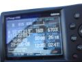
Just in case I got nearby, I coded the geohash into the GPS. That's the first picture in the gallery, clear and easy to see, because it's taken on the ground with the GPS on my lap. Yes, this geohash literally fell in my lap: I found out where we were going. I was to fly to within 2 nm of and circle had to circle a point that was only 4.2 nm from the geohash. That's a minute and a half of flying time away. I was basically told to fly to the geohash and hang out. The way I usually fly to circle a point is to fly directly at it until until I am about three nm away, then turn about 45 degrees from the point until it's abeam me, then circle. Today I decided that I would fly to a point, oh, say 4.2 nm away, then turn and circle from there. Clearly fate wants me to geohash. This was completely dropped in my lap. I could almost not not do it. I was thinking, "I'd better document this really well, or people will think I'm making it up."
Expedition
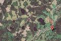
I flew to the point as planned, snapping photos as I went. I saw the GPS go from 0.2 nm to 650' from the point in one blink, then the next blink told me the distance to the next point, the one I would circle, which I had coded next in the route plan. I hit the button to display my actual position, but by then I was past the actual point. What I am particularly proud of about this geohash is the photograph taken out the window as I was maybe two seconds from the geohash. It shows more clearly than any GPS shot that I was there. For comparison I have a screenshot of the day's location in hybrid view on Google Maps and the photograph I took out the window. I know that looking out the window at an angle to find a location on a flat map is a learned skill, so I have put little pink dots in the middle of the matching lakes, at the sharp bend in the road that goes around the burned patch of forest, and along the highway so you can match the two images for yourself. You can't see the geohash location in the image, but you know it is right under my nose. I also changed screens in the GPS to get a position report right past the geohash, but in those few seconds you can see I've travelled through almost 30 seconds of both latitude and longitude.
The mission the client wanted didn't actually work out, because some little clouds (not visible in the photograph) were in the way, so the only thing accomplished in the flight was the geohash. Can anyone beat a $1500 geohash?
Photo Gallery
And here are the pictures.
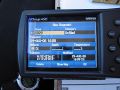
Here is what the geohash coordinates (X029) look like to a Garmin 496.
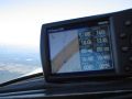
And here is how close they fall to where I was going anyway (A075).
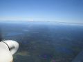
Coming up on the point ...
you can tell I'm exactly where Google said I should be
... even though I took the photo a few seconds later.


Robyn has visited an Easy Geohash
|