| Fri 27 Mar 2009 in Danville, Illinois: 40.2841518, -87.8275845 geohashing.info google osm bing/os kml crox |
After deciding to make this a double-hash day and earn his second Multihash Achievement, Nathan found himself in the graticule just east of his home graticule of (40, -88). The day's coordinates fell in the middle of a harvested corn field some 1,000 feet off a gravel county road. This location was southeast of Armstrong, IL, and southwest of Potomac, IL.
Meetup
This story is a continuation from the journey chronicled here. I strongly recommend reading that story first.
So, arriving back at his car north of Manteno, IL, Nathan was thinking that since he was in the graticule northeast of his home graticule of (40, -88), he should swing due south and pick up the hash point in the (40, -87) graticule.
But there was a problem. Nathan did not have any more flags with him. He had only brought along one of the flags that his friend Brett had given him. What could Nathan do? After thinking about it for a second, he remembered that Brett had told him that those marker flags could be picked up in most any hardware store. Using his GPS, Nathan found that there was an Ace Hardware store only a few miles away in Manteno. So, Nathan went into town, strolled the halls of the Ace Hardware store, and found a 10-pack of hot pink marker flags. Now he was in business!
Plugging in the next set of coordinates into his GPS, Nathan headed south along I-57 South and Illinois State Highway 49. After driving for little more than an hour and after passing through countless small towns, Nathan arrived in Armstrong, IL. The GPS took him southwest of town through some winding county roads. Pulling off at a gravel section of road, he arrived at the closest location to the point he could reach in his car.
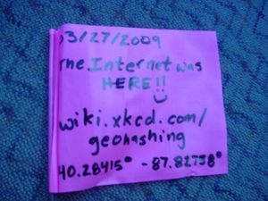
So, using his Sharpie and one of the new marker flags he had just purchased, he created his flag for this particular hash point.
Again, Nathan found himself in another corn field. Thankfully, once again the ground was solid. A little soft and crumbly, perhaps, but solid. The sun was beginning to set and the temperature was dropping, while the wind was picking up. Nathan put on his jacket, grabbed the marker flag, the GPS unit, and his camera and started walking west to the hash point. After about 1,000 feet, he was there.
Even though it was closing in on seven o'clock in the evening, Nathan saw no signs that any other geohashers had made it out to this point today. There was no marker placed that he could see at any rate. Double-checking his GPS unit to make sure he had reached the correct coordinates, Nathan took a picture of himself holding the flag and GPS, then, after planting the flag, took a picture of it with the GPS unit leaning against it.
Nathan started looking around and took some pictures of his surroundings. He saw that the closest homestead was just to his northeast. There was also another homestead a little farther east than the first one. Directly to his east, parked alongside the gravel county road with its flashers flashing was Nathan's car. To his southeast was another homestead, also pretty close. Unfortunately, that was about all there was to see because everything else was harvested corn fields.
So now, Nathan began his march back to the car, hearing human voices in the distance, but not knowing where they were coming from. Nathan also heard the sound of geese honking, but could not see them flying in their V-shaped patterns due to the setting sun in the west. After returning to his car, Nathan took a few more pictures and began his trip back home.
So, after a long afternoon of geohashing, Nathan was hungry and decided to grab some dinner when he got back into town. He managed to get back onto Illinois 49 heading south, and caught Interstate 74 West back to Urbana/Champaign. With it being a Friday during Lent and Nathan being Catholic, he could not eat the meat of a warm-blooded animal. And even though he had just been there for lunch earlier that day, Nathan decided to go to Za's Italian Cafe and have his second meal there. His meal was about the same as it was for lunch, except he drank soda instead of tea and he bought some tiramisu for dessert. Nathan had a side Caeser salad with sun-dried cranberries and then tri-color cheese tortolloni with shrimp, jalapeno peppers, and pineapple topped in a cajun alfredo sauce. Throw in a slice of garlic bread, and Nathan was in heaven.
After finishing his meal, Nathan was sated...for now. He got back in his car and, finally, six hours and 200+ miles after he began, got back home.
Nathan realized that not only did he earn his second double-hash Multihash Achievement in only two weeks of going geohashing, but he also made it to Level 4 Minesweeper Geohash Achievement for visiting not only a hash point in his home graticule, but also visiting hash points in 4 of the 8 surrounding graticules. Only four more to go to complete the achievement.
Thus concludes another adventure in geohashing. Thanks for reading.
Update
After some investigation, Nathan discovered that while his friend Brett had previously attempted to reach hash coordinates in this graticule, he had not succeeded. The Virgin Graticule Achievement goes to the first geohasher who successfully completes a geohash (by actually arriving at the coordinates for a given day) in a particular graticule. Thus, Nathan discovered that he was the first to successfully complete a geohash and, as such, he earns the Virgin Graticule Achievement for the 40, -87 (Danville, Illinois) graticule.
Achievements
Nathan earned the Land geohash achievement
|
Nathan earned the Multihash Achievement
|
Nathan achieved level 4 of the Minesweeper Geohash achievement
|


