2009-04-08 49 -123
| Wed 8 Apr 2009 in Vancouver: 49.5051543, -123.2894917 geohashing.info google osm bing/os kml crox |
The Vancouver graticule just got a whole lot more accessible.
Contents
Planning
Robyn
Robyn has been working on a project to demonstrate the general inaccessibility of geohashes in the Vancouver graticule. Each morning she looks up the geohash and tries to calculate how long it would take her to reach it. Problem is that in order to calculate how long it would take, you have to figure out how you would get there. And once you have done that, you have a plan. And plans just beg to be implemented.
Today's installment of the "my graticule is insane" chronicles noted a point in the middle of Howe Sound, just over two kilometres from the Squamish Highway and more than six kilometres north or south of the nearest access points to the water. (The shore in between is a cliff dropping straight from the highway into the water.) Dutifully Robyn typed in these details, initially estimating 5 km/h for a kayak, but then dropping it to 3 km/h because of unfavourable tides and winds, thus two hours to reach the point, plus driving and kayak set up time. Remember that Robyn owns an inflatable kayak, which she bought yesterday and has not yet removed from the original packaging. Also the weather forecast called for rain.
Robyn, somehow believing that four hours in a kayak she just bought would not be so bad, or perhaps in a fit of bravado, announced her intentions to try the day's geohash. Rhonda promptly contacted Robyn to say she would rent a kayak, and did she have a roof rack? Robyn didn't, and assumed that Rhonda would soon figure out that Robyn was crazy and would wait for a slightly normal geohash. Rhonda, however, is at least as insane as Robyn. Every graticule gets the geohashers it deserves. While Robyn was about ten minutes away from Porteau Cove, Rhonda called to let her know that she was coming. "Great!" said Robyn. Or possibly just "Oh." She meant "Great," but was stunned that someone else would do this. "I'll be the one inflating a kayak," said Robyn.
Rhonda
Rhonda just discovered geohashing a week before, the day of gale force winds over the hash point, and had been waiting for something possible. So when Robyn announced her plans for trying the Anvil Island hash point, Rhonda immediately went looking for kayak rentals.
Unfortunately, places that rent kayaks do not also rent roof racks to carry them on. The rental place that delivered kayaks to your launch point started to offer, until she said "Porteau Cove". "Oh." Silence. "Well, call us back if you find some roof racks then."
At this point, the easiest option was to find out if Robyn had roof racks. Sadly, the easy option did not pan out. Robyn suggested that Rhonda contact another local geohasher, Thepiguy, who had a van which had carried kayaks before. Sadly, that option did not pan out either, as he was stuck indoors all day.
Rhonda did not actually want to buy roof racks, but went looking for a set that would fit her car. After a bit of searching, she found out that roof racks were, minimum, about half the cost of the inflatable kayak that Robyn had linked to on her user page, and suddenly between that and the cost of rental, buying an inflatable kayak became a reasonable idea. A trip to Canada's biggest toy store followed, and with the help of a store manager quite willing to cut packages open (and surprised that this purchase was for a same day trip) she collected kayak, pump with the correct attachment, paddle, and lifejacket, going through the checkout 1h4m before scheduled to meet Robyn at Porteau Cove.
After a quick stop at home to make something portable for lunch and enter the co-ordinates into her GPS, she hit the highway and called Robyn to let her know that she would in fact be there. Robyn sounded flabbergasted (and happy) to receive that message.
Participants
Getting Ready
Rhonda parked right beside Robyn's very easy to spot car, in a vehicle that very notably did not have roof racks, nor a kayak on the roof. Robyn had been watching for a rooftop kayak and so didn't recognize Rhonda as a fellow geohasher until Rhonda waved while stopping.
After the usual introductions ("Hi! Are you from the internet?") both kayaks were inflated and rigged with only occasional reference to the owner's manuals and a small struggle when trying to install a cross brace after inflation when the manual said it was easiest to install before inflation. The manual was right.
Robyn and Rhonda organized GPSs, cameras, water, and snacks into pockets and kayak cargo bags, while T-Rex claimed a position on the bow of Robyn's kayak, holding on to the cargo straps. There was some discussion of optimal launch points and whether it would be faster to walk the kayaks across a rocky, barnacle-encrusted beach to launch a little bit closer to the hash point, or launch at the closest point to the cars. In the end, Rhonda pointed out that there was an actual boat launch and they agreed that would be easier on both ankles and inflatables. Rhonda tucked her camera into the very clever little pocket on the side of her lifejacket for easy access while on the water.
Wearing bright red lifejackets and bright yellow spray skirts, they picked up the kayaks by their convenient carry handles and walked across the parking lot and down the boat ramp. Rhonda was totally right about ease of launch. Robyn, who didn't have proper kayak footwear, managed to board and launch without even getting her feet wet.
Expedition
Launch
At the boat launch, a random stranger with a power boat admired the brand new, bright yellow kayaks. He was pretty impressed to hear that they were inflatable, because they don't actually look like inflatable pool toys until you get close enough to see that they have a fabric hull.
Robyn got her kayak launched first, and paddled around in circles at the end of the boat launch to practise steering and control while Rhonda tried to get her spray skirt to stay on.
"This is the most comfortable kayak I've ever been in!" Robyn called to shore, where Rhonda was finally settled in and trying to push the kayak off the pavement without scraping the bottom too much.
They determined the official launch time as 2:20PM and ducked under the never used Emergency Ferry Terminal to start the trip to the south end of Anvil Island.
Upwind against the tide
As they paddled out of the cove, the headwind became apparent. Every time one or the other stopped paddling for a short rest, the GPS insisted they were going the wrong way. The kayaks climbed the waves like champs, even when whitecaps broke over the bow. T-Rex must have swallowed some salt water because he was a little green, but he didn't drown.
In a relatively quiet band with little wind, Rhonda put some extra effort into her paddling to pull ahead, so she could take a picture of Robyn. She popped her spray skirt up and found her water, snacks, and gloves, but no camera. After a bit of searching inside the kayak, she shrugged and figured either it had slid behind the seat while launching or she had left it in the car, then paddled hard to catch up to Robyn who had passed her while she was distracted.
We did it. We are very tired. More details to come.
Highlights

- easy to inflate
- seal followed us
- eagle
- we got told we looked hot
- wind
- waves
- tide
- five and a half hours in an inflatable kayak
- 9.74km from launch to hash point. Slightly shorter on the return trip.
- Average speed against wind and wave: 2.8km/hr
- we have declared Sevylor the official kayak of the Vancouver graticule
Gallery
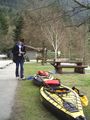
Robyn and the kayaks
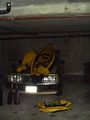
Hey, the bottom comes out! (drying off at home)

