2009-04-23 48 -122
| Thu 23 Apr 2009 in Bellingham: 48.6592781, -122.7917673 geohashing.info google osm bing/os kml crox |
Contents
Location
In woods of unknown ownership on a hilltop near Doebay on Orcas Island. Orcas is a horseshoe-shaped island in the Strait of Juan de Fuca, between Washingston State in the US and Vancouver Island in Canada. It is accessible by a two stage ferry trip, via San Juan Island.
Planning
The 235 km each way bike trip from Vancouver was more than Robyn wanted to tackle, so she decided to drive across the US border to park at Anacortes, the ferry terminal. Consultation of the ferry schedule revealed that she could leave immediately, take the special express lane at the border, and just make the 12:05 ferry, or leave at noon and have time to pick up Rhonda, go through the normal border lane, and arrive in time for the next ferry, the 3:30.
That was kind of late in the day, and the only available return ferry was at 8:05 p.m. It was unlikely we'd be able to bike 66 km and limb up and down a mountain in time to catch that return ferry, so the plan was to bring a tent.
Specifically:
- Take 3:30 ferry from Anacortes to Orcas (arrive Orcas 4:45)
- Bike 33 km to Point Lawrence Road
- Hike 1.5 km up hill to geohash
- Camp!
- Bike back to ferry terminal for 10:20 am ferry
- Arrive Anacortes 11:40 next day
How hard can that be? A 33 km bike ride is a warm-up, really. Robyn had biked 87 km the day before and while the hill was high, it was not the highest point on the island.
Expedition
Robyn
I printed out the best Orcas Island maps I could find and wrote out turn by turn directions to the geohash. I found and attached my bike rack to car using about eight thousand different straps, pointing in all directions, as per the instructions. I attached my bike to bike rack using two teeny little Velcro straps provided and a couple of cargo tie-downs. Then I threw tent, dinosaur, sleeping bag geohashing knapsack and other random camping-related items that I thought might fit in my bicycle panniers into the left side of the back of the car. And then I drove to the SkyTrain to pick up Rhonda.
Rhonda
I broke my rule about not checking the day's location until after I did my morning exercise, and saw Robyn posting about going to Orcas Island for a bike hash. A brief flurry of discussion on the talk page ensued, and I scrapped my planned run, packed camping gear into bike bags, and ran for the seabus, making it on with under a minute to spare.
I had never been to Orcas Island, or any of the San Juan Islands, before, so I really had no idea what to expect. But, Robyn said it should be a fairly light trip with only 32km of cycling each way. No problem.
As I stepped off the skytrain to meet Robyn, I looked around for her car and then saw her, standing on the corner across the street in her distinctive purple cycling jacket. I waved then carefully walked my bike down the stairs from the station and across the street to join her.
Driving to Anacortes
We drove across the Alex Fraser bridge (hey, I was just here) and then merged onto highway 99 (hey, I was just here, too), towards the United States. The programmable sign indicated that southbound border crossing times were 50 minutes at the Peace Arch and 30 minutes at the Pacific crossing, so Robyn took the exit right before the sign for the Pacific crossing. Yeah, right before. You're supposed to take exits after signs. Never mind, Robyn figured she could get onto the overpass to the Pacific crossing from there.
Sure enough, the off-ramp led toward a traffic circle with branches going off in all directions.
"Peace Arch is straight through!" Rhonda said after reading the sign, and Robyn took that exit from the traffic circle.
Right after it wasn't possible to abort and get back into the circle, we both realized that we didn't want the Peace Arch crossing.
But, we were stuck with it, so we shrugged and got into the lineup behind a stalled car and a truck giving it a boost with the jumper cables. Fortunately the car-batching light was red, so that wasn't actually holding us up, just holding us back about three car lengths from the regular stop line. We shut off the engine to wait, because this is genuinely the longest red light ever.
About half an hour or so later, the light turned green and the batch of cars we were in turned on their engines and joined the regular inching-forward lineup.
Robyn attempted to explain the game of geohashing to the border guard, who seemed somewhat baffled that we didn't know if we were coming back that night or the next day and didn't seem to care. He asked about fresh fruits and vegetables, which Robyn assured him consisted of a banana she ate in the lineup, then waved us on without a search. As we drove into the US, Rhonda suddenly remembered that she had packed fresh fruit in her bag as part of her food contribution to the trip.
The road dropped us down the I-5 exit ramp into Blaine (hey, we were both just here!) and after turning onto the Blaine main street, turning around, and getting onto the I-5 southbound onramp with the "end detour" sign directly across the street from the exit ramp we had just been on, we were on our way.
Because we had crossed the border in good time, we decided to take highway 20 for the scenic route, going through twisty forest mountain roads, then open straight farmland roads, then past a power station, before rejoining I-5 heading for Anacortes.
The signs pointed the way, and we very quickly found ourselves at the ferry terminal. In the lanes approaching the ticket booths, in fact. Rhonda spotted a parking lot to the right and down a slope, so Robyn turned around in the (empty) ticketing lanes and back to the parking lot entrance ramp.
We had all of our stuff arranged on the bikes and the car locked up with its parking paid for as the loudspeaker splattered the announcement for our ferry all over the ferry terminal. We looked left, right, and straight at the ticket booths, and opted to ride back up the entrance ramp rather than try to lift our bikes up the rather long flight of stairs or chance the gravel end of the lot that may or may not connect with the terminal beyond the ticket booths.
The ticket agent assured us that there was no extra charge for dinosaurs on the ferry, and we rode past all the cars lined up in tidy rows to the pedestrian waiting area to board ahead of the cars. Way down at the far end of the ferry were bicycles stencilled on the wall and short ropes to tie the bikes down. Robyn also put a wheel chock in front of her bike's wheel. Then we went up to get some food and enjoy the trip to Orcas Island.
Orcas Island
Camping

Dinosaurs aren't very cuddly for sleeping with.
Back to the ferry
Heading home
After
Just got back. Rhonda, don't look at where today's Bellingham geohash is. You'll so kick yourself for us not finding an Internet cafe in Anacortes. We should have asked those ladies iPhones on the ferry!
Augh!!! -- Rhonda 23:03, 24 April 2009 (UTC)
Photos
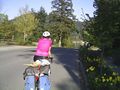
Just cresting a hill.
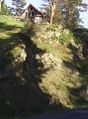
Deer in somebody's front yard, up a cliff.
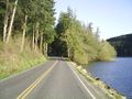
Beside a lake. One of the only flat spots in the ride.
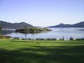
Short stop at a park to take in the view.


