2009-06-28 50 11
| Sun 28 Jun 2009 in 50,11: 50.9102060, 11.3062207 geohashing.info google osm bing/os kml crox |
This hash again seemed fairly easy to do - according to my new strategy which allows me to visit all hashpoints that are visible on my bike map (which covers an area of about 30-40km around my home). So I started after breakfast, and this time my knowledge about the little edgie was at least sufficient to save the hashpoint before starting and then just following the (straight, but what does it matter?) line to the destination. The trip by bike was okay, I found a nice bike way from Mellingen (Ilmtal-Radweg) and when the point was almost reached and I was afraid I'd have to climb up to the meadow through the nettles, there even was a grassy way leading to the point itself. After taking the photos, I took a look on the map and decided to go back another route using some ways that were unknown to me - in fact, the direct way from Oettern to Kiliansroda through the forest was even a little bit adventurous for mountain bikers. From Kiliansroda on, I had an easy way home - and a pretty easy hash, again, was found...
---Paintedhell
- Photo Gallery
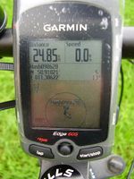
This time, the proof looks a little more professional already. Wish I would have been fast enough to take a photo of the "destination reached" screen...

The hash, near a deer stand.
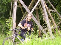
Tux, Karl and me at the hash.
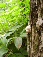
The snail from the riddle: it climbs up the tree 1m by day and slides back 0.5m by night...


Achievements
Three consecutive geohashes - so I broke my record...
Juja earned the Consecutive geohash achievement
|