2009-08-04 51 8
From Geohashing
Revision as of 17:04, 4 August 2009 by imported>El muerte verde (New page: {{meetup graticule | lat=51 | lon=8 | date=2009-08-04 }} __NOTOC__ == Location == A field just outside of Ehringhausen. == Participants == * El muerte verde ...)
| Tue 4 Aug 2009 in 51,8: 51.6550512, 8.4456251 geohashing.info google osm bing/os kml crox |
Location
A field just outside of Ehringhausen.
Participants
Expedition
pending
Tracklog
I had to recreate the tracklog in http://maps.google.com for the lack of knowledge about the GPS prevented me from logging the ride. The distance overall distance was actually a bit more because I had to cycle around a construction side in Schloß Neuhaus on ways I couldn't mark in maps.google.com thus resulting in 60 km of total way cycled. [1]
Photos
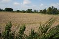
The field with the hashpoint
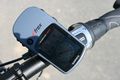
Just 4 meters? That's good enough!
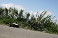
My bike and picnic. Sadly the battery died on me after this photo. *facepalm*


Achievements
El muerte verde earned the Land geohash achievement
|
El muerte verde earned the Bicycle geohash achievement
|
El muerte verde earned the Tron achievement
|
El muerte verde earned the Picnic achievement
|