2010-07-16 39 -105
From Geohashing
Revision as of 18:36, 16 July 2010 by imported>Ralph (→Expedition)
| Fri 16 Jul 2010 in 39,-105: 39.5731138, -105.1707132 geohashing.info google osm bing/os kml crox |
Location
Ken Caryl Ranch, just off C-470.
Plans
The dogs and I are headed for a morning hike.
Participants
Ralph, Tanna and Hendrix
Expedition
A fifteen mile highway drive took us to Ken Caryl Ranch, a neighborhood located in a pretty cool valley between the hogback just SW of Denver and the foothills behind it. The hogback is a flat piece of rock that was pushed up by the Rocky Mountains forming, and presently lies at a tilt, so you can see the diagonal stratifications in it. Up near Boulder, this forms the Flat Irons,
Photos
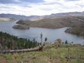
Pretty darn gorgeous.
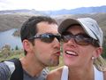
Pretty darn gorgeous part II (on the right).
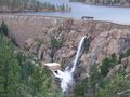
Bernoulli's principle!
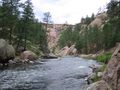
South Platte
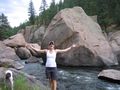
The river is thiiiiiiiis wide.
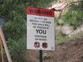
Thanks, mom. I guess I won't be getting any dessert either.


Achievements
Ralph earned the No trespassing consolation prize
|
Ralph earned the Drag-along achievement
|